Zolotyy Potik geodata
Zolotyy Potik (Ternopil) is a populated place; located in Ukraine in Europe/Kiev (GMT+3) time zone. With population of 2,343 people, there are 1054 cities with bigger population in this country. Compared to other cities in Ukraine, 64.1% of cities are located further ↓South; 84.5% of cities are located further →East and 94.2% of cities have lower elevation than Zolotyy Potik. Note1


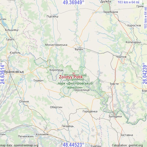
Zolotyy Potik GPS coordinates[2]
48° 54' 34.2" North, 25° 20' 21.336" East
| Map corner | latitude | longitude |
|---|---|---|
| Upper-left | 49.36949°, | 24.63614° |
| Center: | 48.9095°, | 25.33926° |
| Lower-right: | 48.44523°, | 26.04239° |
| Map W x H: | 102.8×102.8 km | = 63.9×63.9mi |
| max Lat: | 52.18903° ⇑35.9% North |
| Zolotyy Potik: | 48.9095° |
| min Lat: | ⇓64.1% South 44.39214° |
| min Long | Zolotyy Potik | max Long |
| 22.20555° | 25.33926° | 40.13222° |
| W 15.5%⇐ | ⇒84.5% E |
Elevation
Elevation of Zolotyy Potik is 349 m = 1145 ft, and this is 193.2 m = 634 ft above average elevation for this country.
| Max E: |
886 m = 2907 ft | 5.8% |
| Zolotyy Potik | 349 m 1145 ft | |
| Avg. | 155.8 m = 511 ft | |
Min E: |
-3 m = -10 ft | 94.2% |
See also: Ukraine elevation on elevation.city.
Geographical zone
Zolotyy Potik is located in North temperate zone (between Tropic of Cancer and the Arctic Circle). Distance of this North polar circle is 1962.9 km =1219.7 mi to North.| Distance of | km | miles | from Zolotyy Potik |
|---|---|---|---|
| North Pole | 4568.8 | 2838.9 | to North |
| Arctic Circle | 1962.9 | 1219.7 | to North |
| Tropic Cancer | 2832.3 | 1759.9 | to South |
| Equator | 5438.2 | 3379.1 | to South |


Nearby cities:
15 places around Zolotyy Potik: (largest is in red/bold)
• Belaya
34.2 km =21.3 mi,  67°
67°
• Buchach
17.4 km =10.8 mi,  11°
11°
• Chernelytsya
12.5 km =7.8 mi,  149°
149°
• Chernyatyn
28.8 km =17.9 mi,  163°
163°
• Chornoliztsi
33.6 km =20.9 mi,  254°
254°
• Druzhba
16.9 km =10.5 mi,  28°
28°
• Horodenka
28.9 km =18 mi, 155°
• Monastyrys’ka
23.4 km =14.5 mi,  328°
328°
• Nyrkiv
21.8 km =13.5 mi,  118°
118°
• Obertyn
26.4 km =16.4 mi,  208°
208°
• Tlumach
25.1 km =15.6 mi,  258°
258°
• Tovste
29.1 km =18.1 mi,  103°
103°
• Yablonovka
9.7 km =6 mi,  50°
50°
• Yagel’nitsa Stara
28.3 km =17.6 mi, 74°
• Yahil’nytsya
29.8 km =18.5 mi,  82°
82°
Sources, notices
• [Note1] Compared only with cities in Ukraine existing in our database
• [Src1] Map data: © OpenStreetMap contributors (CC-BY-SA)
• [Src2] Other city data from geonames.org with taken over terms of usage.
• [Src3] Geographical zone / Annual Mean Temperature by Robert A. Rohde @ Wikipedia
