Nyrkiv geodata
Nyrkiv (Ternopil) is a populated place; located in Ukraine in Europe/Kiev (GMT+3) time zone. With population of 1,013 people, there are 1372 cities with bigger population in this country. Compared to other cities in Ukraine, 62.4% of cities are located further ↓South; 83.2% of cities are located further →East and 92.9% of cities have lower elevation than Nyrkiv. Note1


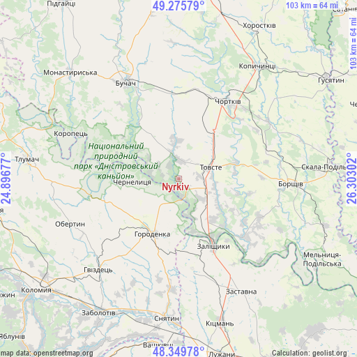
Nyrkiv GPS coordinates[2]
48° 48' 53.712" North, 25° 35' 59.604" East
| Map corner | latitude | longitude |
|---|---|---|
| Upper-left | 49.27579°, | 24.89677° |
| Center: | 48.81492°, | 25.59989° |
| Lower-right: | 48.34978°, | 26.30302° |
| Map W x H: | 103×103 km | = 64×64mi |
| max Lat: | 52.18903° ⇑37.6% North |
| Nyrkiv: | 48.81492° |
| min Lat: | ⇓62.4% South 44.39214° |
| min Long | Nyrkiv | max Long |
| 22.20555° | 25.59989° | 40.13222° |
| W 16.8%⇐ | ⇒83.2% E |
Elevation
Elevation of Nyrkiv is 330 m = 1083 ft, and this is 174.2 m = 572 ft above average elevation for this country.
| Max E: |
886 m = 2907 ft | 7.1% |
| Nyrkiv | 330 m 1083 ft | |
| Avg. | 155.8 m = 511 ft | |
Min E: |
-3 m = -10 ft | 92.9% |
See also: Ukraine elevation on elevation.city.
Geographical zone
Nyrkiv is located in North temperate zone (between Tropic of Cancer and the Arctic Circle). Distance of this North polar circle is 1973.5 km =1226.3 mi to North.| Distance of | km | miles | from Nyrkiv |
|---|---|---|---|
| North Pole | 4579.4 | 2845.5 | to North |
| Arctic Circle | 1973.5 | 1226.3 | to North |
| Tropic Cancer | 2821.8 | 1753.4 | to South |
| Equator | 5427.7 | 3372.6 | to South |


Nearby cities:
15 places around Nyrkiv: (largest is in red/bold)
• Belaya
26.9 km =16.7 mi,  27°
27°
• Buchach
31.6 km =19.6 mi,  330°
330°
• Chernelytsya
12.8 km =8 mi,  268°
268°
• Chernyatyn
20.5 km =12.7 mi,  212°
212°
• Chortkiv
26.7 km =16.6 mi, 32°
• Druzhba
27.6 km =17.1 mi,  336°
336°
• Horodenka
17.4 km =10.8 mi,  204°
204°
• Kadubivtsi
28.6 km =17.8 mi,  154°
154°
• Kostryzhivka
19.7 km =12.2 mi,  155°
155°
• Tovste
9.9 km =6.2 mi,  69°
69°
• Yablonovka
20.3 km =12.6 mi, 325°
• Yagel’nitsa Stara
20 km =12.4 mi,  24°
24°
• Yahil’nytsya
17.7 km =11 mi,  36°
36°
• Zalishchyky
21.6 km =13.4 mi, 152°
• Zolotyy Potik
21.8 km =13.5 mi,  298°
298°
Sources, notices
• [Note1] Compared only with cities in Ukraine existing in our database
• [Src1] Map data: © OpenStreetMap contributors (CC-BY-SA)
• [Src2] Other city data from geonames.org with taken over terms of usage.
• [Src3] Geographical zone / Annual Mean Temperature by Robert A. Rohde @ Wikipedia
