Voloka geodata
Voloka (Chernivtsi Oblast') is a populated place; located in Ukraine in Europe/Kiev (GMT+3) time zone. With population of 2,915 people, there are 968 cities with bigger population in this country. Compared to other cities in Ukraine, 52.5% of cities are located further ↑North; 81.3% of cities are located further →East and 79.9% of cities have lower elevation than Voloka. Note1


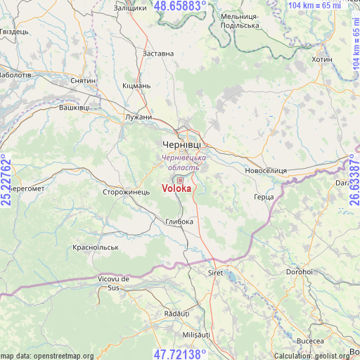
Voloka GPS coordinates[2]
48° 11' 32.1" North, 25° 55' 50.664" East
| Map corner | latitude | longitude |
|---|---|---|
| Upper-left | 48.65883°, | 25.22762° |
| Center: | 48.19225°, | 25.93074° |
| Lower-right: | 47.72138°, | 26.63387° |
| Map W x H: | 104.2×104.2 km | = 64.7×64.7mi |
| max Lat: | 52.18903° ⇑52.5% North |
| Voloka: | 48.19225° |
| min Lat: | ⇓47.5% South 44.39214° |
| min Long | Voloka | max Long |
| 22.20555° | 25.93074° | 40.13222° |
| W 18.7%⇐ | ⇒81.3% E |
Elevation
Elevation of Voloka is 246 m = 807 ft, and this is 90.2 m = 296 ft above average elevation for this country.
| Max E: |
886 m = 2907 ft | 20.1% |
| Voloka | 246 m 807 ft | |
| Avg. | 155.8 m = 511 ft | |
Min E: |
-3 m = -10 ft | 79.9% |
See also: Ukraine elevation on elevation.city.
Geographical zone
Voloka is located in North temperate zone (between Tropic of Cancer and the Arctic Circle). Distance of this North polar circle is 2042.7 km =1269.3 mi to North.| Distance of | km | miles | from Voloka |
|---|---|---|---|
| North Pole | 4648.6 | 2888.5 | to North |
| Arctic Circle | 2042.7 | 1269.3 | to North |
| Tropic Cancer | 2752.6 | 1710.4 | to South |
| Equator | 5358.5 | 3329.6 | to South |


Nearby cities:
15 places around Voloka: (largest is in red/bold)
• Boyany
16.9 km =10.5 mi,  58°
58°
• Chernivtsi
11.1 km =6.9 mi,  3°
3°
• Chudey
27.7 km =17.2 mi,  235°
235°
• Davydivka
28.3 km =17.6 mi,  253°
253°
• Hlyboka
11.4 km =7.1 mi,  180°
180°
• Kitsman’
30.5 km =19 mi,  336°
336°
• Luzhany
22.5 km =14 mi,  328°
328°
• Marshintsy
26.9 km =16.7 mi,  83°
83°
• Molodiya
7.6 km =4.7 mi, 62°
• Novoselytsya
25 km =15.5 mi, 83°
• Nyzhni Petrivtsi
23.9 km =14.9 mi,  220°
220°
• Ropcha
14.1 km =8.8 mi, 235°
• Shypyntsi
24.6 km =15.3 mi, 326°
• Storozhynets’
15.9 km =9.9 mi,  258°
258°
• Yizhivtsi
26.2 km =16.3 mi,  229°
229°
Sources, notices
• [Note1] Compared only with cities in Ukraine existing in our database
• [Src1] Map data: © OpenStreetMap contributors (CC-BY-SA)
• [Src2] Other city data from geonames.org with taken over terms of usage.
• [Src3] Geographical zone / Annual Mean Temperature by Robert A. Rohde @ Wikipedia
