Hlyboka geodata
Hlyboka (Chernivtsi Oblast') is a seat of a second-order administrative division; located in Ukraine in Europe/Kiev (GMT+3) time zone. With population of 8,942 people, there are 400 cities with bigger population in this country. Compared to other cities in Ukraine, 54.9% of cities are located further ↑North; 81.3% of cities are located further →East and 94.1% of cities have lower elevation than Hlyboka. Note1


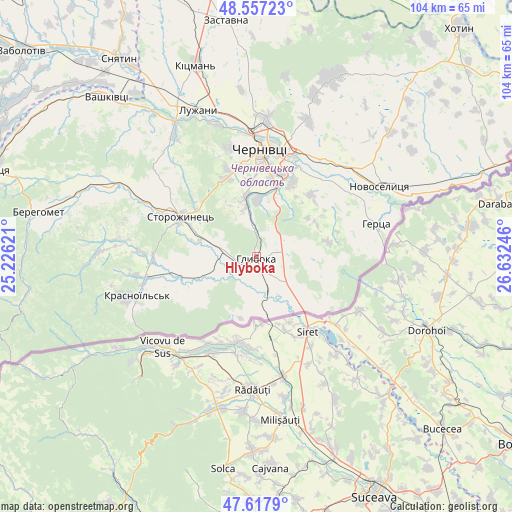
Hlyboka GPS coordinates[2]
48° 5' 22.956" North, 25° 55' 45.588" East
| Map corner | latitude | longitude |
|---|---|---|
| Upper-left | 48.55723°, | 25.22621° |
| Center: | 48.08971°, | 25.92933° |
| Lower-right: | 47.6179°, | 26.63246° |
| Map W x H: | 104.4×104.4 km | = 64.9×64.9mi |
| max Lat: | 52.18903° ⇑54.9% North |
| Hlyboka: | 48.08971° |
| min Lat: | ⇓45.1% South 44.39214° |
| min Long | Hlyboka | max Long |
| 22.20555° | 25.92933° | 40.13222° |
| W 18.7%⇐ | ⇒81.3% E |
Elevation
Elevation of Hlyboka is 348 m = 1142 ft, and this is 192.2 m = 631 ft above average elevation for this country.
| Max E: |
886 m = 2907 ft | 5.9% |
| Hlyboka | 348 m 1142 ft | |
| Avg. | 155.8 m = 511 ft | |
Min E: |
-3 m = -10 ft | 94.1% |
See also: Ukraine elevation on elevation.city.
Geographical zone
Hlyboka is located in North temperate zone (between Tropic of Cancer and the Arctic Circle). Distance of this North polar circle is 2054.1 km =1276.4 mi to North.| Distance of | km | miles | from Hlyboka |
|---|---|---|---|
| North Pole | 4660 | 2895.6 | to North |
| Arctic Circle | 2054.1 | 1276.4 | to North |
| Tropic Cancer | 2741.2 | 1703.3 | to South |
| Equator | 5347.1 | 3322.5 | to South |


Nearby cities:
15 places around Hlyboka: (largest is in red/bold)
• Boyany
24.9 km =15.5 mi,  35°
35°
• Chernivtsi
22.5 km =14 mi,  2°
2°
• Chudey
23.2 km =14.4 mi,  259°
259°
• Davydivka
27.3 km =17 mi,  277°
277°
• Kitsman’
41.1 km =25.5 mi,  342°
342°
• Luzhany
32.8 km =20.4 mi, 339°
• Marshintsy
30.4 km =18.9 mi,  62°
62°
• Molodiya
16.3 km =10.1 mi,  24°
24°
• Novoselytsya
28.8 km =17.9 mi, 59°
• Nyzhni Petrivtsi
16.8 km =10.4 mi,  246°
246°
• Ropcha
12 km =7.5 mi,  286°
286°
• Shypyntsi
34.7 km =21.6 mi, 337°
• Storozhynets’
17.6 km =10.9 mi,  298°
298°
• Voloka
11.4 km =7.1 mi, 0°
• Yizhivtsi
20.6 km =12.8 mi, 254°
Sources, notices
• [Note1] Compared only with cities in Ukraine existing in our database
• [Src1] Map data: © OpenStreetMap contributors (CC-BY-SA)
• [Src2] Other city data from geonames.org with taken over terms of usage.
• [Src3] Geographical zone / Annual Mean Temperature by Robert A. Rohde @ Wikipedia
