Chernivtsi geodata
Chernivtsi (Chernivtsi Oblast') is a seat of a first-order administrative division; located in Ukraine in Europe/Kiev (GMT+3) time zone. With population of 236,250 people, there are 26 cities with bigger population in this country. Compared to other cities in Ukraine, 50.3% of cities are located further ↑North; 81.2% of cities are located further →East and 75.7% of cities have lower elevation than Chernivtsi. Note1


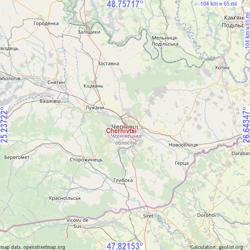
Chernivtsi GPS coordinates[2]
48° 17' 29.364" North, 25° 56' 25.224" East
| Map corner | latitude | longitude |
|---|---|---|
| Upper-left | 48.75717°, | 25.23722° |
| Center: | 48.29149°, | 25.94034° |
| Lower-right: | 47.82153°, | 26.64347° |
| Map W x H: | 104×104 km | = 64.6×64.6mi |
| max Lat: | 52.18903° ⇑50.3% North |
| Chernivtsi: | 48.29149° |
| min Lat: | ⇓49.7% South 44.39214° |
| min Long | Chernivtsi | max Long |
| 22.20555° | 25.94034° | 40.13222° |
| W 18.8%⇐ | ⇒81.2% E |
Elevation
Elevation of Chernivtsi is 228 m = 748 ft, and this is 72.2 m = 237 ft above average elevation for this country.
| Max E: |
886 m = 2907 ft | 24.3% |
| Chernivtsi | 228 m 748 ft | |
| Avg. | 155.8 m = 511 ft | |
Min E: |
-3 m = -10 ft | 75.7% |
See also: Chernivtsi elevation on elevation.city.
Geographical zone
Chernivtsi is located in North temperate zone (between Tropic of Cancer and the Arctic Circle). Distance of this North polar circle is 2031.7 km =1262.4 mi to North.| Distance of | km | miles | from Chernivtsi |
|---|---|---|---|
| North Pole | 4637.6 | 2881.7 | to North |
| Arctic Circle | 2031.7 | 1262.4 | to North |
| Tropic Cancer | 2763.6 | 1717.2 | to South |
| Equator | 5369.5 | 3336.5 | to South |


Nearby cities:
15 places around Chernivtsi: (largest is in red/bold)
• Boyany
13.9 km =8.6 mi,  99°
99°
• Hlyboka
22.5 km =14 mi,  182°
182°
• Kitsman’
21.2 km =13.2 mi,  322°
322°
• Klishkivtsi
28.4 km =17.6 mi,  56°
56°
• Luzhany
14.9 km =9.3 mi,  303°
303°
• Marshintsy
27.3 km =17 mi,  107°
107°
• Molodiya
9.7 km =6 mi,  141°
141°
• Novoselytsya
25.4 km =15.8 mi, 108°
• Ropcha
22.7 km =14.1 mi,  212°
212°
• Shypyntsi
17.2 km =10.7 mi, 303°
• Sniatyn
32.4 km =20.1 mi, 302°
• Storozhynets’
21.6 km =13.4 mi,  229°
229°
• Verenchanka
31.8 km =19.8 mi,  333°
333°
• Voloka
11.1 km =6.9 mi, 183°
• Zastavna
26.7 km =16.6 mi,  344°
344°
In other languages:
- In France: Tchernivtsi
- In German: Tschernowitz, Czernowitz
- In Italian: Černivci
- In Russian: Черновцы
- In Chinese: 切爾諾夫策
Sources, notices
• [Note1] Compared only with cities in Ukraine existing in our database
• [Src1] Map data: © OpenStreetMap contributors (CC-BY-SA)
• [Src2] Other city data from geonames.org with taken over terms of usage.
• [Src3] Geographical zone / Annual Mean Temperature by Robert A. Rohde @ Wikipedia
