Novoselytsya geodata
Novoselytsya (Chernivtsi Oblast') is a seat of a second-order administrative division; located in Ukraine in Europe/Kiev (GMT+3) time zone. With population of 8,088 people, there are 436 cities with bigger population in this country. Compared to other cities in Ukraine, 51.8% of cities are located further ↑North; 79.9% of cities are located further →East and 50.9% of cities have lower elevation than Novoselytsya. Note1


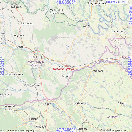
Novoselytsya GPS coordinates[2]
48° 13' 9.516" North, 26° 15' 55.116" East
| Map corner | latitude | longitude |
|---|---|---|
| Upper-left | 48.68565°, | 25.56219° |
| Center: | 48.21931°, | 26.26531° |
| Lower-right: | 47.74869°, | 26.96844° |
| Map W x H: | 104.2×104.2 km | = 64.7×64.7mi |
| max Lat: | 52.18903° ⇑51.8% North |
| Novoselytsya: | 48.21931° |
| min Lat: | ⇓48.2% South 44.39214° |
| min Long | Novoselytsya | max Long |
| 22.20555° | 26.26531° | 40.13222° |
| W 20.1%⇐ | ⇒79.9% E |
Elevation
Elevation of Novoselytsya is 139 m = 456 ft, and this is 16.8 m = 55 ft below average elevation for this country.
| Max E: |
886 m = 2907 ft | 49.1% |
| Avg. | 155.8 m = 511 ft | |
| Novoselytsya | 139 m = 456 ft | |
Min E: |
-3 m = -10 ft | 50.9% |
See also: Ukraine elevation on elevation.city.
Geographical zone
Novoselytsya is located in North temperate zone (between Tropic of Cancer and the Arctic Circle). Distance of this North polar circle is 2039.7 km =1267.4 mi to North.| Distance of | km | miles | from Novoselytsya |
|---|---|---|---|
| North Pole | 4645.6 | 2886.6 | to North |
| Arctic Circle | 2039.7 | 1267.4 | to North |
| Tropic Cancer | 2755.6 | 1712.2 | to South |
| Equator | 5361.5 | 3331.5 | to South |


Nearby cities:
15 places around Novoselytsya: (largest is in red/bold)
• Boyany
11.8 km =7.3 mi,  299°
299°
• Chernivtsi
25.4 km =15.8 mi,  288°
288°
• Hlyboka
28.8 km =17.9 mi,  239°
239°
• Khotyn
36.1 km =22.4 mi,  27°
27°
• Kitsman’
44.5 km =27.7 mi, 304°
• Klishkivtsi
23.6 km =14.7 mi,  359°
359°
• Luzhany
39.9 km =24.8 mi, 293°
• Marshintsy
1.9 km =1.2 mi,  95°
95°
• Molodiya
18.1 km =11.2 mi,  271°
271°
• Nyzhni Petrivtsi
45.5 km =28.3 mi, 242°
• Ropcha
38.1 km =23.7 mi,  253°
253°
• Shypyntsi
42.2 km =26.2 mi, 294°
• Storozhynets’
40.9 km =25.4 mi,  261°
261°
• Voloka
25 km =15.5 mi, 263°
• Zhvanets
40.2 km =25 mi,  24°
24°
Sources, notices
• [Note1] Compared only with cities in Ukraine existing in our database
• [Src1] Map data: © OpenStreetMap contributors (CC-BY-SA)
• [Src2] Other city data from geonames.org with taken over terms of usage.
• [Src3] Geographical zone / Annual Mean Temperature by Robert A. Rohde @ Wikipedia
