Storozhynets’ geodata
Storozhynets’ (Chernivtsi Oblast') is a seat of a second-order administrative division; located in Ukraine in Europe/Kiev (GMT+3) time zone. In our database, there are 1661 cities with bigger population. Compared to other cities in Ukraine, 53.1% of cities are located further ↑North; 82.6% of cities are located further →East and 95.3% of cities have lower elevation than Storozhynets’. Note1


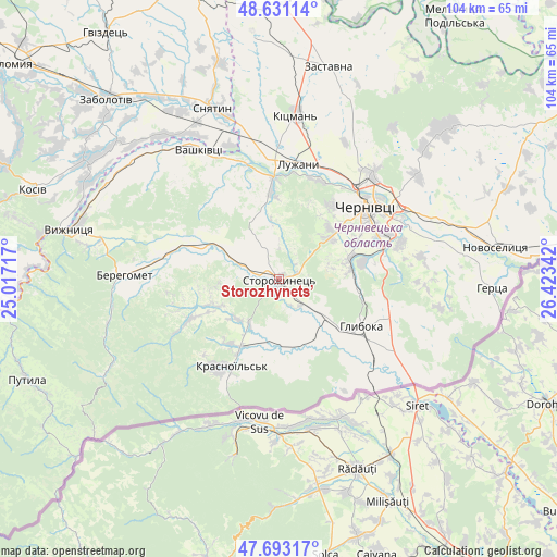
Storozhynets’ GPS coordinates[2]
48° 9' 51.48" North, 25° 43' 13.044" East
| Map corner | latitude | longitude |
|---|---|---|
| Upper-left | 48.63114°, | 25.01717° |
| Center: | 48.1643°, | 25.72029° |
| Lower-right: | 47.69317°, | 26.42342° |
| Map W x H: | 104.3×104.3 km | = 64.8×64.8mi |
| max Lat: | 52.18903° ⇑53.1% North |
| Storozhynets’: | 48.1643° |
| min Lat: | ⇓46.9% South 44.39214° |
| min Long | Storozhynets’ | max Long |
| 22.20555° | 25.72029° | 40.13222° |
| W 17.4%⇐ | ⇒82.6% E |
Elevation
Elevation of Storozhynets’ is 368 m = 1207 ft, and this is 212.2 m = 696 ft above average elevation for this country.
| Max E: |
886 m = 2907 ft | 4.7% |
| Storozhynets’ | 368 m 1207 ft | |
| Avg. | 155.8 m = 511 ft | |
Min E: |
-3 m = -10 ft | 95.3% |
See also: Ukraine elevation on elevation.city.
Geographical zone
Storozhynets’ is located in North temperate zone (between Tropic of Cancer and the Arctic Circle). Distance of this North polar circle is 2045.8 km =1271.2 mi to North.| Distance of | km | miles | from Storozhynets’ |
|---|---|---|---|
| North Pole | 4651.7 | 2890.4 | to North |
| Arctic Circle | 2045.8 | 1271.2 | to North |
| Tropic Cancer | 2749.4 | 1708.4 | to South |
| Equator | 5355.4 | 3327.7 | to South |


Nearby cities:
15 places around Storozhynets’: (largest is in red/bold)
• Berehomet
27.6 km =17.1 mi,  273°
273°
• Chernivtsi
21.6 km =13.4 mi,  49°
49°
• Chudey
14.4 km =8.9 mi,  210°
210°
• Davydivka
12.5 km =7.8 mi,  247°
247°
• Hlyboka
17.6 km =10.9 mi,  118°
118°
• Kitsman’
31.2 km =19.4 mi,  6°
6°
• Luzhany
22.6 km =14 mi, 9°
• Molodiya
23.3 km =14.5 mi,  73°
73°
• Myhove
25.3 km =15.7 mi, 268°
• Nyzhni Petrivtsi
15.1 km =9.4 mi,  179°
179°
• Ropcha
6.4 km =4 mi,  140°
140°
• Shypyntsi
23.7 km =14.7 mi,  4°
4°
• Vashkivtsi
29 km =18 mi,  327°
327°
• Voloka
15.9 km =9.9 mi,  78°
78°
• Yizhivtsi
14.5 km =9 mi,  197°
197°
Sources, notices
• [Note1] Compared only with cities in Ukraine existing in our database
• [Src1] Map data: © OpenStreetMap contributors (CC-BY-SA)
• [Src2] Other city data from geonames.org with taken over terms of usage.
• [Src3] Geographical zone / Annual Mean Temperature by Robert A. Rohde @ Wikipedia
