Letychiv geodata
Letychiv (Khmelnytskyi) is a seat of a second-order administrative division; located in Ukraine in Europe/Kiev (GMT+3) time zone. With population of 10,669 people, there are 341 cities with bigger population in this country. Compared to other cities in Ukraine, 72.3% of cities are located further ↓South; 76.8% of cities are located further →East and 85.5% of cities have lower elevation than Letychiv. Note1


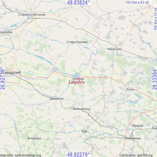
Letychiv GPS coordinates[2]
49° 22' 57.468" North, 27° 37' 49.836" East
| Map corner | latitude | longitude |
|---|---|---|
| Upper-left | 49.83824°, | 26.92739° |
| Center: | 49.38263°, | 27.63051° |
| Lower-right: | 48.92276°, | 28.33364° |
| Map W x H: | 101.8×101.8 km | = 63.3×63.3mi |
| max Lat: | 52.18903° ⇑27.7% North |
| Letychiv: | 49.38263° |
| min Lat: | ⇓72.3% South 44.39214° |
| min Long | Letychiv | max Long |
| 22.20555° | 27.63051° | 40.13222° |
| W 23.2%⇐ | ⇒76.8% E |
Elevation
Elevation of Letychiv is 278 m = 912 ft, and this is 122.2 m = 401 ft above average elevation for this country.
| Max E: |
886 m = 2907 ft | 14.5% |
| Letychiv | 278 m 912 ft | |
| Avg. | 155.8 m = 511 ft | |
Min E: |
-3 m = -10 ft | 85.5% |
See also: Ukraine elevation on elevation.city.
Geographical zone
Letychiv is located in North temperate zone (between Tropic of Cancer and the Arctic Circle). Distance of this North polar circle is 1910.3 km =1187 mi to North.| Distance of | km | miles | from Letychiv |
|---|---|---|---|
| North Pole | 4516.2 | 2806.2 | to North |
| Arctic Circle | 1910.3 | 1187 | to North |
| Tropic Cancer | 2884.9 | 1792.6 | to South |
| Equator | 5490.8 | 3411.8 | to South |


Nearby cities:
15 places around Letychiv: (largest is in red/bold)
• Bar
34.2 km =21.3 mi,  173°
173°
• Brailiv
49.8 km =30.9 mi,  127°
127°
• Derazhnya
19 km =11.8 mi,  228°
228°
• Khmelnytskyi
46.1 km =28.6 mi,  275°
275°
• Khmilnyk
30.8 km =19.1 mi,  50°
50°
• Kopayhorod
59.4 km =36.9 mi, 168°
• Krasyliv
56.1 km =34.9 mi,  302°
302°
• Lityn
33.2 km =20.6 mi,  101°
101°
• Medzhybizh
17.4 km =10.8 mi,  290°
290°
• Stara Syniava
24.5 km =15.2 mi,  358°
358°
• Starokostiantyniv
51.8 km =32.2 mi,  323°
323°
• Suslivtsi
6.3 km =3.9 mi,  12°
12°
• Ulaniv
50.2 km =31.2 mi, 46°
• Vinkivtsi
48.1 km =29.9 mi,  216°
216°
• Zhmerynka
52 km =32.3 mi,  137°
137°
Sources, notices
• [Note1] Compared only with cities in Ukraine existing in our database
• [Src1] Map data: © OpenStreetMap contributors (CC-BY-SA)
• [Src2] Other city data from geonames.org with taken over terms of usage.
• [Src3] Geographical zone / Annual Mean Temperature by Robert A. Rohde @ Wikipedia
