Bar geodata
Bar (Vinnyts'ka) is a seat of a second-order administrative division; located in Ukraine in Europe/Kiev (GMT+3) time zone. With population of 16,641 people, there are 230 cities with bigger population in this country. Compared to other cities in Ukraine, 68% of cities are located further ↓South; 76.6% of cities are located further →East and 86.3% of cities have lower elevation than Bar. Note1


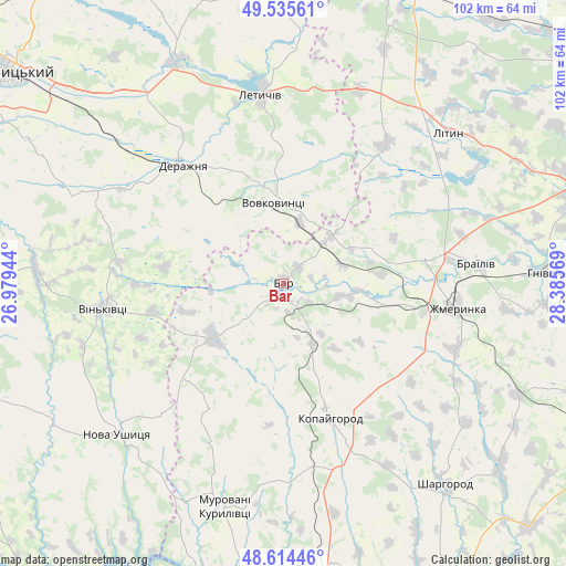
Bar GPS coordinates[2]
49° 4' 37.812" North, 27° 40' 57.216" East
| Map corner | latitude | longitude |
|---|---|---|
| Upper-left | 49.53561°, | 26.97944° |
| Center: | 49.07717°, | 27.68256° |
| Lower-right: | 48.61446°, | 28.38569° |
| Map W x H: | 102.4×102.4 km | = 63.6×63.6mi |
| max Lat: | 52.18903° ⇑32% North |
| Bar: | 49.07717° |
| min Lat: | ⇓68% South 44.39214° |
| min Long | Bar | max Long |
| 22.20555° | 27.68256° | 40.13222° |
| W 23.4%⇐ | ⇒76.6% E |
Elevation
Elevation of Bar is 282 m = 925 ft, and this is 126.2 m = 414 ft above average elevation for this country.
| Max E: |
886 m = 2907 ft | 13.7% |
| Bar | 282 m 925 ft | |
| Avg. | 155.8 m = 511 ft | |
Min E: |
-3 m = -10 ft | 86.3% |
See also: Ukraine elevation on elevation.city.
Geographical zone
Bar is located in North temperate zone (between Tropic of Cancer and the Arctic Circle). Distance of this North polar circle is 1944.3 km =1208.1 mi to North.| Distance of | km | miles | from Bar |
|---|---|---|---|
| North Pole | 4550.2 | 2827.4 | to North |
| Arctic Circle | 1944.3 | 1208.1 | to North |
| Tropic Cancer | 2851 | 1771.5 | to South |
| Equator | 5456.9 | 3390.8 | to South |


Nearby cities:
15 places around Bar: (largest is in red/bold)
• Brailiv
36 km =22.4 mi,  84°
84°
• Derazhnya
28 km =17.4 mi,  319°
319°
• Kopayhorod
25.6 km =15.9 mi,  161°
161°
• Letychiv
34.2 km =21.3 mi,  353°
353°
• Lityn
40 km =24.9 mi,  46°
46°
• Medzhybizh
44.8 km =27.8 mi,  333°
333°
• Murafa
52 km =32.3 mi,  131°
131°
• Murovani Kurylivtsi
41.1 km =25.5 mi,  196°
196°
• Nova Ushytsya
40 km =24.9 mi,  228°
228°
• Sharhorod
45.8 km =28.5 mi,  141°
141°
• Suslivtsi
40.2 km =25 mi,  356°
356°
• Sutysky
53.7 km =33.4 mi,  94°
94°
• Vendychany
52.4 km =32.6 mi,  171°
171°
• Vinkivtsi
32.9 km =20.4 mi,  261°
261°
• Zhmerynka
31.6 km =19.6 mi,  98°
98°
Sources, notices
• [Note1] Compared only with cities in Ukraine existing in our database
• [Src1] Map data: © OpenStreetMap contributors (CC-BY-SA)
• [Src2] Other city data from geonames.org with taken over terms of usage.
• [Src3] Geographical zone / Annual Mean Temperature by Robert A. Rohde @ Wikipedia
