Kopayhorod geodata
Kopayhorod (Vinnyts'ka) is a populated place; located in Ukraine in Europe/Kiev (GMT+3) time zone. With population of 1,437 people, there are 1228 cities with bigger population in this country. Compared to other cities in Ukraine, 63.2% of cities are located further ↓South; 76.3% of cities are located further →East and 84% of cities have lower elevation than Kopayhorod. Note1


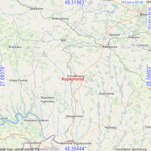
Kopayhorod GPS coordinates[2]
48° 51' 33.012" North, 27° 47' 48.84" East
| Map corner | latitude | longitude |
|---|---|---|
| Upper-left | 49.31963°, | 27.09378° |
| Center: | 48.85917°, | 27.7969° |
| Lower-right: | 48.39444°, | 28.50003° |
| Map W x H: | 102.9×102.9 km | = 63.9×63.9mi |
| max Lat: | 52.18903° ⇑36.8% North |
| Kopayhorod: | 48.85917° |
| min Lat: | ⇓63.2% South 44.39214° |
| min Long | Kopayhorod | max Long |
| 22.20555° | 27.7969° | 40.13222° |
| W 23.7%⇐ | ⇒76.3% E |
Elevation
Elevation of Kopayhorod is 267 m = 876 ft, and this is 111.2 m = 365 ft above average elevation for this country.
| Max E: |
886 m = 2907 ft | 16% |
| Kopayhorod | 267 m 876 ft | |
| Avg. | 155.8 m = 511 ft | |
Min E: |
-3 m = -10 ft | 84% |
See also: Ukraine elevation on elevation.city.
Geographical zone
Kopayhorod is located in North temperate zone (between Tropic of Cancer and the Arctic Circle). Distance of this North polar circle is 1968.5 km =1223.2 mi to North.| Distance of | km | miles | from Kopayhorod |
|---|---|---|---|
| North Pole | 4574.4 | 2842.4 | to North |
| Arctic Circle | 1968.5 | 1223.2 | to North |
| Tropic Cancer | 2826.7 | 1756.4 | to South |
| Equator | 5432.6 | 3375.7 | to South |


Nearby cities:
15 places around Kopayhorod: (largest is in red/bold)
• Bar
25.6 km =15.9 mi,  341°
341°
• Brailiv
39.2 km =24.4 mi,  44°
44°
• Chernivtsi
42.3 km =26.3 mi,  146°
146°
• Derazhnya
52.7 km =32.7 mi,  329°
329°
• Mohyliv-Podilskyi
45.9 km =28.5 mi,  179°
179°
• Murafa
32.3 km =20.1 mi,  108°
108°
• Murovani Kurylivtsi
25.3 km =15.7 mi,  233°
233°
• Nova Ushytsya
38.3 km =23.8 mi,  266°
266°
• Novodnistrovs’k
40.3 km =25 mi,  220°
220°
• Serebriya
45.2 km =28.1 mi,  187°
187°
• Sharhorod
23.4 km =14.5 mi,  119°
119°
• Sutysky
49.7 km =30.9 mi,  65°
65°
• Vendychany
27.5 km =17.1 mi, 180°
• Vinkivtsi
45.4 km =28.2 mi,  295°
295°
• Zhmerynka
30.3 km =18.8 mi,  49°
49°
Sources, notices
• [Note1] Compared only with cities in Ukraine existing in our database
• [Src1] Map data: © OpenStreetMap contributors (CC-BY-SA)
• [Src2] Other city data from geonames.org with taken over terms of usage.
• [Src3] Geographical zone / Annual Mean Temperature by Robert A. Rohde @ Wikipedia
