Verkhniachka geodata
Verkhniachka (Cherkasy) is a populated place; located in Ukraine in Europe/Kiev (GMT+3) time zone. With population of 4,130 people, there are 746 cities with bigger population in this country. Compared to other cities in Ukraine, 62.6% of cities are located further ↓South; 67.5% of cities are located further →East and 80.3% of cities have lower elevation than Verkhniachka. Note1


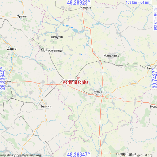
Verkhniachka GPS coordinates[2]
48° 49' 42.564" North, 30° 2' 22.452" East
| Map corner | latitude | longitude |
|---|---|---|
| Upper-left | 49.28923°, | 29.33645° |
| Center: | 48.82849°, | 30.03957° |
| Lower-right: | 48.36347°, | 30.7427° |
| Map W x H: | 102.9×102.9 km | = 63.9×63.9mi |
| max Lat: | 52.18903° ⇑37.4% North |
| Verkhniachka: | 48.82849° |
| min Lat: | ⇓62.6% South 44.39214° |
| min Long | Verkhniachka | max Long |
| 22.20555° | 30.03957° | 40.13222° |
| W 32.5%⇐ | ⇒67.5% E |
Elevation
Elevation of Verkhniachka is 248 m = 814 ft, and this is 92.2 m = 302 ft above average elevation for this country.
| Max E: |
886 m = 2907 ft | 19.7% |
| Verkhniachka | 248 m 814 ft | |
| Avg. | 155.8 m = 511 ft | |
Min E: |
-3 m = -10 ft | 80.3% |
See also: Ukraine elevation on elevation.city.
Geographical zone
Verkhniachka is located in North temperate zone (between Tropic of Cancer and the Arctic Circle). Distance of this North polar circle is 1972 km =1225.3 mi to North.| Distance of | km | miles | from Verkhniachka |
|---|---|---|---|
| North Pole | 4577.8 | 2844.5 | to North |
| Arctic Circle | 1972 | 1225.3 | to North |
| Tropic Cancer | 2823.3 | 1754.3 | to South |
| Equator | 5429.2 | 3373.5 | to South |


Nearby cities:
15 places around Verkhniachka: (largest is in red/bold)
• Babanka
32.7 km =20.3 mi,  113°
113°
• Buky
39.6 km =24.6 mi,  42°
42°
• Dashiv
48.9 km =30.4 mi,  293°
293°
• Haisyn
47.6 km =29.6 mi,  267°
267°
• Khrystynivka
4.8 km =3 mi,  252°
252°
• Mankivka
26.2 km =16.3 mi,  55°
55°
• Monastyryshche
24.9 km =15.5 mi,  316°
316°
• Nove-Misto
23 km =14.3 mi, 317°
• Perehonivka
48 km =29.8 mi,  132°
132°
• Talne
48.4 km =30.1 mi,  82°
82°
• Tanske
26 km =16.2 mi,  98°
98°
• Teplyk
28.2 km =17.5 mi,  230°
230°
• Tsibulev
31.2 km =19.4 mi,  333°
333°
• Uman
16.1 km =10 mi,  123°
123°
• Zhashkiv
46.6 km =29 mi,  6°
6°
Sources, notices
• [Note1] Compared only with cities in Ukraine existing in our database
• [Src1] Map data: © OpenStreetMap contributors (CC-BY-SA)
• [Src2] Other city data from geonames.org with taken over terms of usage.
• [Src3] Geographical zone / Annual Mean Temperature by Robert A. Rohde @ Wikipedia
