Uman geodata
Uman (Cherkasy) is a seat of a second-order administrative division; located in Ukraine in Europe/Kiev (GMT+3) time zone. With population of 87,658 people, there are 51 cities with bigger population in this country. Compared to other cities in Ukraine, 61.4% of cities are located further ↓South; 66.5% of cities are located further →East and 72.6% of cities have lower elevation than Uman. Note1


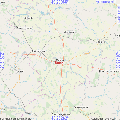
Uman GPS coordinates[2]
48° 44' 54.168" North, 30° 13' 18.624" East
| Map corner | latitude | longitude |
|---|---|---|
| Upper-left | 49.20986°, | 29.51872° |
| Center: | 48.74838°, | 30.22184° |
| Lower-right: | 48.28262°, | 30.92497° |
| Map W x H: | 103.1×103.1 km | = 64.1×64.1mi |
| max Lat: | 52.18903° ⇑38.6% North |
| Uman: | 48.74838° |
| min Lat: | ⇓61.4% South 44.39214° |
| min Long | Uman | max Long |
| 22.20555° | 30.22184° | 40.13222° |
| W 33.5%⇐ | ⇒66.5% E |
Elevation
Elevation of Uman is 215 m = 705 ft, and this is 59.2 m = 194 ft above average elevation for this country.
| Max E: |
886 m = 2907 ft | 27.4% |
| Uman | 215 m 705 ft | |
| Avg. | 155.8 m = 511 ft | |
Min E: |
-3 m = -10 ft | 72.6% |
See also: Uman elevation on elevation.city.
Geographical zone
Uman is located in North temperate zone (between Tropic of Cancer and the Arctic Circle). Distance of this North polar circle is 1980.9 km =1230.9 mi to North.| Distance of | km | miles | from Uman |
|---|---|---|---|
| North Pole | 4586.8 | 2850.1 | to North |
| Arctic Circle | 1980.9 | 1230.9 | to North |
| Tropic Cancer | 2814.4 | 1748.8 | to South |
| Equator | 5420.3 | 3368 | to South |


Nearby cities:
15 places around Uman: (largest is in red/bold)
• Babanka
17.2 km =10.7 mi,  104°
104°
• Buky
40.5 km =25.2 mi,  19°
19°
• Hlybochok
44.3 km =27.5 mi,  72°
72°
• Holovanivs’k
44.2 km =27.5 mi,  156°
156°
• Khrystynivka
19.4 km =12.1 mi,  292°
292°
• Mankivka
25.3 km =15.7 mi, 18°
• Monastyryshche
40.7 km =25.3 mi,  311°
311°
• Nove-Misto
38.7 km =24 mi, 311°
• Novoarkhanhel’s’k
44.9 km =27.9 mi, 102°
• Perehonivka
32.2 km =20 mi,  137°
137°
• Talne
38 km =23.6 mi, 65°
• Tanske
13.4 km =8.3 mi, 68°
• Teplyk
36.2 km =22.5 mi,  255°
255°
• Tsibulev
45.8 km =28.5 mi,  323°
323°
• Verkhniachka
16.1 km =10 mi,  303°
303°
Sources, notices
• [Note1] Compared only with cities in Ukraine existing in our database
• [Src1] Map data: © OpenStreetMap contributors (CC-BY-SA)
• [Src2] Other city data from geonames.org with taken over terms of usage.
• [Src3] Geographical zone / Annual Mean Temperature by Robert A. Rohde @ Wikipedia
