Khrystynivka geodata
Khrystynivka (Cherkasy) is a seat of a second-order administrative division; located in Ukraine in Europe/Kiev (GMT+3) time zone. With population of 14,056 people, there are 270 cities with bigger population in this country. Compared to other cities in Ukraine, 62.5% of cities are located further ↓South; 67.9% of cities are located further →East and 80.3% of cities have lower elevation than Khrystynivka. Note1


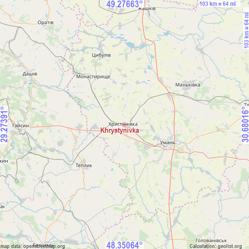
Khrystynivka GPS coordinates[2]
48° 48' 56.772" North, 29° 58' 37.308" East
| Map corner | latitude | longitude |
|---|---|---|
| Upper-left | 49.27663°, | 29.27391° |
| Center: | 48.81577°, | 29.97703° |
| Lower-right: | 48.35064°, | 30.68016° |
| Map W x H: | 103×103 km | = 64×64mi |
| max Lat: | 52.18903° ⇑37.5% North |
| Khrystynivka: | 48.81577° |
| min Lat: | ⇓62.5% South 44.39214° |
| min Long | Khrystynivka | max Long |
| 22.20555° | 29.97703° | 40.13222° |
| W 32.1%⇐ | ⇒67.9% E |
Elevation
Elevation of Khrystynivka is 248 m = 814 ft, and this is 92.2 m = 302 ft above average elevation for this country.
| Max E: |
886 m = 2907 ft | 19.7% |
| Khrystynivka | 248 m 814 ft | |
| Avg. | 155.8 m = 511 ft | |
Min E: |
-3 m = -10 ft | 80.3% |
See also: Ukraine elevation on elevation.city.
Geographical zone
Khrystynivka is located in North temperate zone (between Tropic of Cancer and the Arctic Circle). Distance of this North polar circle is 1973.4 km =1226.2 mi to North.| Distance of | km | miles | from Khrystynivka |
|---|---|---|---|
| North Pole | 4579.3 | 2845.4 | to North |
| Arctic Circle | 1973.4 | 1226.2 | to North |
| Tropic Cancer | 2821.9 | 1753.4 | to South |
| Equator | 5427.8 | 3372.7 | to South |


Nearby cities:
15 places around Khrystynivka: (largest is in red/bold)
• Babanka
36.5 km =22.7 mi,  108°
108°
• Buky
43.8 km =27.2 mi,  45°
45°
• Dashiv
45.4 km =28.2 mi,  297°
297°
• Haisyn
43 km =26.7 mi,  269°
269°
• Mankivka
30.8 km =19.1 mi,  57°
57°
• Monastyryshche
23.2 km =14.4 mi,  327°
327°
• Nove-Misto
21.4 km =13.3 mi, 329°
• Orativ
52.9 km =32.9 mi,  321°
321°
• Perehonivka
50.6 km =31.4 mi,  128°
128°
• Tanske
30.4 km =18.9 mi,  94°
94°
• Teplyk
23.8 km =14.8 mi,  225°
225°
• Tsibulev
30.8 km =19.1 mi,  342°
342°
• Uman
19.4 km =12.1 mi, 112°
• Verkhniachka
4.8 km =3 mi,  72°
72°
• Zhashkiv
48.8 km =30.3 mi,  11°
11°
Sources, notices
• [Note1] Compared only with cities in Ukraine existing in our database
• [Src1] Map data: © OpenStreetMap contributors (CC-BY-SA)
• [Src2] Other city data from geonames.org with taken over terms of usage.
• [Src3] Geographical zone / Annual Mean Temperature by Robert A. Rohde @ Wikipedia
