Teplyk geodata
Teplyk (Vinnyts'ka) is a seat of a second-order administrative division; located in Ukraine in Europe/Kiev (GMT+3) time zone. With population of 6,604 people, there are 531 cities with bigger population in this country. Compared to other cities in Ukraine, 59.4% of cities are located further ↓South; 69.1% of cities are located further →East and 68.9% of cities have lower elevation than Teplyk. Note1


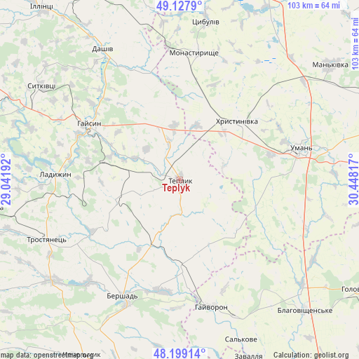
Teplyk GPS coordinates[2]
48° 39' 56.376" North, 29° 44' 42.144" East
| Map corner | latitude | longitude |
|---|---|---|
| Upper-left | 49.1279°, | 29.04192° |
| Center: | 48.66566°, | 29.74504° |
| Lower-right: | 48.19914°, | 30.44817° |
| Map W x H: | 103.3×103.3 km | = 64.2×64.2mi |
| max Lat: | 52.18903° ⇑40.6% North |
| Teplyk: | 48.66566° |
| min Lat: | ⇓59.4% South 44.39214° |
| min Long | Teplyk | max Long |
| 22.20555° | 29.74504° | 40.13222° |
| W 30.9%⇐ | ⇒69.1% E |
Elevation
Elevation of Teplyk is 201 m = 659 ft, and this is 45.2 m = 148 ft above average elevation for this country.
| Max E: |
886 m = 2907 ft | 31.1% |
| Teplyk | 201 m 659 ft | |
| Avg. | 155.8 m = 511 ft | |
Min E: |
-3 m = -10 ft | 68.9% |
See also: Ukraine elevation on elevation.city.
Geographical zone
Teplyk is located in North temperate zone (between Tropic of Cancer and the Arctic Circle). Distance of this North polar circle is 1990.1 km =1236.6 mi to North.| Distance of | km | miles | from Teplyk |
|---|---|---|---|
| North Pole | 4595.9 | 2855.8 | to North |
| Arctic Circle | 1990.1 | 1236.6 | to North |
| Tropic Cancer | 2805.2 | 1743.1 | to South |
| Equator | 5411.1 | 3362.3 | to South |


Nearby cities:
15 places around Teplyk: (largest is in red/bold)
• Bershad
37.1 km =23.1 mi,  206°
206°
• Dashiv
44.3 km =27.5 mi,  328°
328°
• Haisyn
30.7 km =19.1 mi,  301°
301°
• Hayvoron
37.4 km =23.2 mi,  165°
165°
• Khrystynivka
23.8 km =14.8 mi,  45°
45°
• Ladyzhyn
37.4 km =23.2 mi,  273°
273°
• Monastyryshche
36.4 km =22.6 mi,  6°
6°
• Nove-Misto
35.6 km =22.1 mi, 9°
• Obodivka
46.7 km =29 mi,  231°
231°
• Tanske
49.5 km =30.8 mi,  73°
73°
• Trostyanets’
41.3 km =25.7 mi,  245°
245°
• Tsibulev
46.6 km =29 mi, 9°
• Uman
36.2 km =22.5 mi,  75°
75°
• Verkhniachka
28.2 km =17.5 mi, 50°
• Viytivka
30.5 km =19 mi, 209°
Sources, notices
• [Note1] Compared only with cities in Ukraine existing in our database
• [Src1] Map data: © OpenStreetMap contributors (CC-BY-SA)
• [Src2] Other city data from geonames.org with taken over terms of usage.
• [Src3] Geographical zone / Annual Mean Temperature by Robert A. Rohde @ Wikipedia
