Liubar geodata
Liubar (Zhytomyr) is a seat of a second-order administrative division; located in Ukraine in Europe/Kiev (GMT+3) time zone. With population of 2,351 people, there are 1053 cities with bigger population in this country. Compared to other cities in Ukraine, 82.1% of cities are located further ↓South; 76.4% of cities are located further →East and 77.5% of cities have lower elevation than Liubar. Note1


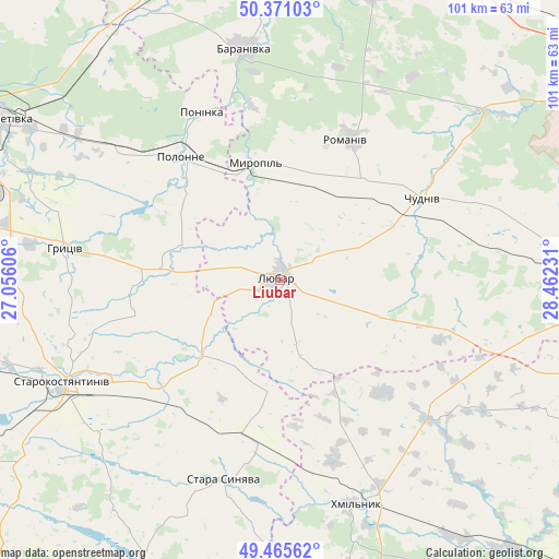
Liubar GPS coordinates[2]
49° 55' 13.62" North, 27° 45' 33.048" East
| Map corner | latitude | longitude |
|---|---|---|
| Upper-left | 50.37103°, | 27.05606° |
| Center: | 49.92045°, | 27.75918° |
| Lower-right: | 49.46562°, | 28.46231° |
| Map W x H: | 100.7×100.7 km | = 62.6×62.6mi |
| max Lat: | 52.18903° ⇑17.9% North |
| Liubar: | 49.92045° |
| min Lat: | ⇓82.1% South 44.39214° |
| min Long | Liubar | max Long |
| 22.20555° | 27.75918° | 40.13222° |
| W 23.6%⇐ | ⇒76.4% E |
Elevation
Elevation of Liubar is 236 m = 774 ft, and this is 80.2 m = 263 ft above average elevation for this country.
| Max E: |
886 m = 2907 ft | 22.5% |
| Liubar | 236 m 774 ft | |
| Avg. | 155.8 m = 511 ft | |
Min E: |
-3 m = -10 ft | 77.5% |
See also: Ukraine elevation on elevation.city.
Geographical zone
Liubar is located in North temperate zone (between Tropic of Cancer and the Arctic Circle). Distance of this North polar circle is 1850.5 km =1149.8 mi to North.| Distance of | km | miles | from Liubar |
|---|---|---|---|
| North Pole | 4456.4 | 2769.1 | to North |
| Arctic Circle | 1850.5 | 1149.8 | to North |
| Tropic Cancer | 2944.7 | 1829.8 | to South |
| Equator | 5550.6 | 3449 | to South |


Nearby cities:
15 places around Liubar: (largest is in red/bold)
• Baranivka
42.4 km =26.3 mi,  350°
350°
• Bykivka
44.4 km =27.6 mi,  21°
21°
• Chudniv
29.5 km =18.3 mi,  60°
60°
• Denyshi
56.4 km =35 mi,  54°
54°
• Dovbysh
52.9 km =32.9 mi, 17°
• Khmilnyk
42.6 km =26.5 mi,  160°
160°
• Novoselytsya
23.9 km =14.9 mi,  314°
314°
• Polonne
28.8 km =17.9 mi,  321°
321°
• Polyanka
37.9 km =23.5 mi, 352°
• Poninka
33.4 km =20.8 mi,  331°
331°
• Romaniv
28.1 km =17.5 mi,  25°
25°
• Stara Syniava
36.7 km =22.8 mi,  195°
195°
• Starokostiantyniv
43.8 km =27.2 mi,  245°
245°
• Suslivtsi
54.2 km =33.7 mi,  188°
188°
• Ulaniv
36.7 km =22.8 mi,  133°
133°
Sources, notices
• [Note1] Compared only with cities in Ukraine existing in our database
• [Src1] Map data: © OpenStreetMap contributors (CC-BY-SA)
• [Src2] Other city data from geonames.org with taken over terms of usage.
• [Src3] Geographical zone / Annual Mean Temperature by Robert A. Rohde @ Wikipedia
