Shats’k geodata
Shats’k (Volyn) is a seat of a second-order administrative division; located in Ukraine in Europe/Kiev (GMT+3) time zone. With population of 5,708 people, there are 588 cities with bigger population in this country. Compared to other cities in Ukraine, 97.9% of cities are located further ↓South; 92.9% of cities are located further →East and 59.6% of cities have lower elevation than Shats’k. Note1


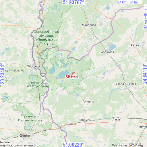
Shats’k GPS coordinates[2]
51° 30' 7.488" North, 23° 56' 17.016" East
| Map corner | latitude | longitude |
|---|---|---|
| Upper-left | 51.93767°, | 23.23494° |
| Center: | 51.50208°, | 23.93806° |
| Lower-right: | 51.06229°, | 24.64119° |
| Map W x H: | 97.3×97.3 km | = 60.5×60.5mi |
| max Lat: | 52.18903° ⇑2.1% North |
| Shats’k: | 51.50208° |
| min Lat: | ⇓97.9% South 44.39214° |
| min Long | Shats’k | max Long |
| 22.20555° | 23.93806° | 40.13222° |
| W 7.1%⇐ | ⇒92.9% E |
Elevation
Elevation of Shats’k is 167 m = 548 ft, and this is 11.2 m = 37 ft above average elevation for this country.
| Max E: |
886 m = 2907 ft | 40.4% |
| Shats’k | 167 m 548 ft | |
| Avg. | 155.8 m = 511 ft | |
Min E: |
-3 m = -10 ft | 59.6% |
See also: Ukraine elevation on elevation.city.
Geographical zone
Shats’k is located in North temperate zone (between Tropic of Cancer and the Arctic Circle). Distance of this North polar circle is 1674.7 km =1040.6 mi to North.| Distance of | km | miles | from Shats’k |
|---|---|---|---|
| North Pole | 4280.6 | 2659.8 | to North |
| Arctic Circle | 1674.7 | 1040.6 | to North |
| Tropic Cancer | 3120.6 | 1939.1 | to South |
| Equator | 5726.5 | 3558.3 | to South |


Nearby cities:
15 places around Shats’k: (largest is in red/bold)
• Hołoby
87.6 km =54.4 mi,  121°
121°
• Kamin-Kashyrskyi
71.8 km =44.6 mi,  79°
79°
• Kovel
62.3 km =38.7 mi, 120°
• Liuboml
31.5 km =19.6 mi,  167°
167°
• Novovolyns’k
87.7 km =54.5 mi, 169°
• Nuyno
67.4 km =41.9 mi,  85°
85°
• Oles’k
46.9 km =29.1 mi,  158°
158°
• Pidrichchya
60.1 km =37.3 mi, 81°
• Pishcha
14.4 km =8.9 mi,  325°
325°
• Rakiv Lis
69.5 km =43.2 mi, 78°
• Ratne
44.9 km =27.9 mi,  65°
65°
• Stara Vyzhivka
35.5 km =22.1 mi,  101°
101°
• Svityaz’
5.9 km =3.7 mi,  247°
247°
• Turiys’k
61.6 km =38.3 mi,  138°
138°
• Volodymyr-Volynskyi
77.1 km =47.9 mi, 159°
Sources, notices
• [Note1] Compared only with cities in Ukraine existing in our database
• [Src1] Map data: © OpenStreetMap contributors (CC-BY-SA)
• [Src2] Other city data from geonames.org with taken over terms of usage.
• [Src3] Geographical zone / Annual Mean Temperature by Robert A. Rohde @ Wikipedia
