Baryshivka geodata
Baryshivka (Kyiv) is a seat of a second-order administrative division; located in Ukraine in Europe/Kiev (GMT+3) time zone. With population of 10,762 people, there are 337 cities with bigger population in this country. Compared to other cities in Ukraine, 89% of cities are located further ↓South; 59.9% of cities are located further →East and 62.1% of cities have higher elevation than Baryshivka. Note1


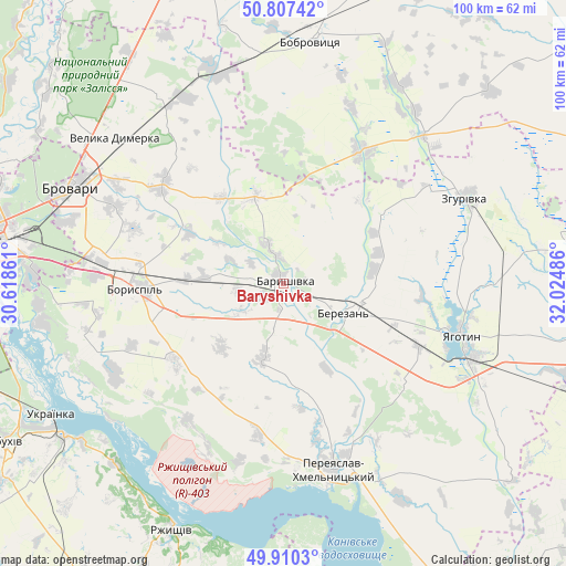
Baryshivka GPS coordinates[2]
50° 21' 39.528" North, 31° 19' 18.228" East
| Map corner | latitude | longitude |
|---|---|---|
| Upper-left | 50.80742°, | 30.61861° |
| Center: | 50.36098°, | 31.32173° |
| Lower-right: | 49.9103°, | 32.02486° |
| Map W x H: | 99.8×99.7 km | = 62×62mi |
| max Lat: | 52.18903° ⇑11% North |
| Baryshivka: | 50.36098° |
| min Lat: | ⇓89% South 44.39214° |
| min Long | Baryshivka | max Long |
| 22.20555° | 31.32173° | 40.13222° |
| W 40.1%⇐ | ⇒59.9% E |
Elevation
Elevation of Baryshivka is 100 m = 328 ft, and this is 55.8 m = 183 ft below average elevation for this country.
| Max E: |
886 m = 2907 ft | 62.1% |
| Avg. | 155.8 m = 511 ft | |
| Baryshivka | 100 m = 328 ft | |
Min E: |
-3 m = -10 ft | 37.9% |
See also: Ukraine elevation on elevation.city.
Geographical zone
Baryshivka is located in North temperate zone (between Tropic of Cancer and the Arctic Circle). Distance of this North polar circle is 1801.6 km =1119.5 mi to North.| Distance of | km | miles | from Baryshivka |
|---|---|---|---|
| North Pole | 4407.4 | 2738.6 | to North |
| Arctic Circle | 1801.6 | 1119.5 | to North |
| Tropic Cancer | 2993.7 | 1860.2 | to South |
| Equator | 5599.6 | 3479.4 | to South |


Nearby cities:
15 places around Baryshivka: (largest is in red/bold)
• Bobrovytsya
43.2 km =26.8 mi,  6°
6°
• Boryspil’
26 km =16.2 mi,  267°
267°
• Brovary
40.4 km =25.1 mi,  295°
295°
• Kirove
14.3 km =8.9 mi, 273°
• Knyazhichi
39.8 km =24.7 mi,  286°
286°
• Korniyivka
11.7 km =7.3 mi,  58°
58°
• Pereiaslav-Khmelnytskyi
33.9 km =21.1 mi,  164°
164°
• Prolisky
38.6 km =24 mi, 274°
• Stayki
43.3 km =26.9 mi,  223°
223°
• Trebukhiv
32.7 km =20.3 mi, 294°
• Velyka Dymerka
39.3 km =24.4 mi,  311°
311°
• Voronkov
33.7 km =20.9 mi,  242°
242°
• Vytachiv
42.2 km =26.2 mi,  229°
229°
• Yahotyn
32.6 km =20.3 mi,  106°
106°
• Zgurovka
36.4 km =22.6 mi, 64°
Sources, notices
• [Note1] Compared only with cities in Ukraine existing in our database
• [Src1] Map data: © OpenStreetMap contributors (CC-BY-SA)
• [Src2] Other city data from geonames.org with taken over terms of usage.
• [Src3] Geographical zone / Annual Mean Temperature by Robert A. Rohde @ Wikipedia
