Kirove geodata
Kirove (Zaporizhia) is a populated place; located in Ukraine in Europe/Zaporozhye (GMT+3) time zone. With population of 3,291 people, there are 870 cities with bigger population in this country. Compared to other cities in Ukraine, 59.6% of cities are located further ↑North; 85.1% of cities are located further ←West and 82.5% of cities have higher elevation than Kirove. Note1


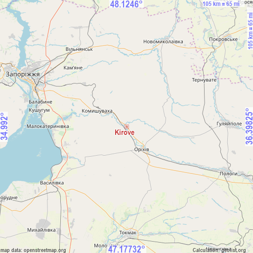
Kirove GPS coordinates[2]
47° 39' 11.196" North, 35° 41' 42.432" East
| Map corner | latitude | longitude |
|---|---|---|
| Upper-left | 48.1246°, | 34.992° |
| Center: | 47.65311°, | 35.69512° |
| Lower-right: | 47.17732°, | 36.39825° |
| Map W x H: | 105.3×105.3 km | = 65.4×65.4mi |
| max Lat: | 52.18903° ⇑59.6% North |
| Kirove: | 47.65311° |
| min Lat: | ⇓40.4% South 44.39214° |
| min Long | Kirove | max Long |
| 22.20555° | 35.69512° | 40.13222° |
| W 85.1%⇐ | ⇒14.9% E |
Elevation
Elevation of Kirove is 37 m = 121 ft, and this is 118.8 m = 390 ft below average elevation for this country.
| Max E: |
886 m = 2907 ft | 82.5% |
| Avg. | 155.8 m = 511 ft | |
| Kirove | 37 m = 121 ft | |
Min E: |
-3 m = -10 ft | 17.5% |
See also: Ukraine elevation on elevation.city.
Geographical zone
Kirove is located in North temperate zone (between Tropic of Cancer and the Arctic Circle). Distance of this North polar circle is 2102.6 km =1306.5 mi to North.| Distance of | km | miles | from Kirove |
|---|---|---|---|
| North Pole | 4708.5 | 2925.7 | to North |
| Arctic Circle | 2102.6 | 1306.5 | to North |
| Tropic Cancer | 2692.6 | 1673.1 | to South |
| Equator | 5298.5 | 3292.3 | to South |


Nearby cities:
15 places around Kirove: (largest is in red/bold)
• Hulyaypole
42 km =26.1 mi,  88°
88°
• Komyshuvakha
14.2 km =8.8 mi,  299°
299°
• Kushuhum
37 km =23 mi,  280°
280°
• Mala Tokmachka
19.8 km =12.3 mi,  131°
131°
• Malokaterynivka
32.9 km =20.4 mi,  270°
270°
• Novomykolayivka
39.5 km =24.5 mi,  23°
23°
• Orikhiv
11.7 km =7.3 mi,  144°
144°
• Polohy
45.9 km =28.5 mi,  114°
114°
• Preobrazhenka
12.8 km =8 mi, 134°
• Ternuvate
37.9 km =23.5 mi,  58°
58°
• Tokmak
44.3 km =27.5 mi,  178°
178°
• Vasylivka
39.7 km =24.7 mi,  232°
232°
• Vil’nyans’k
37.7 km =23.4 mi,  329°
329°
• Zaliznychne
35.2 km =21.9 mi, 90°
• Zaporizhia
42.2 km =26.2 mi, 296°
Sources, notices
• [Note1] Compared only with cities in Ukraine existing in our database
• [Src1] Map data: © OpenStreetMap contributors (CC-BY-SA)
• [Src2] Other city data from geonames.org with taken over terms of usage.
• [Src3] Geographical zone / Annual Mean Temperature by Robert A. Rohde @ Wikipedia
