Ternopil geodata
Ternopil is a seat of a first-order administrative division; located in Ukraine in Europe/Kiev (GMT+3) time zone. With population of 235,676 people, there are 27 cities with bigger population in this country. Compared to other cities in Ukraine, 75.6% of cities are located further ↓South; 83.2% of cities are located further →East and 91.4% of cities have lower elevation than Ternopil. Note1


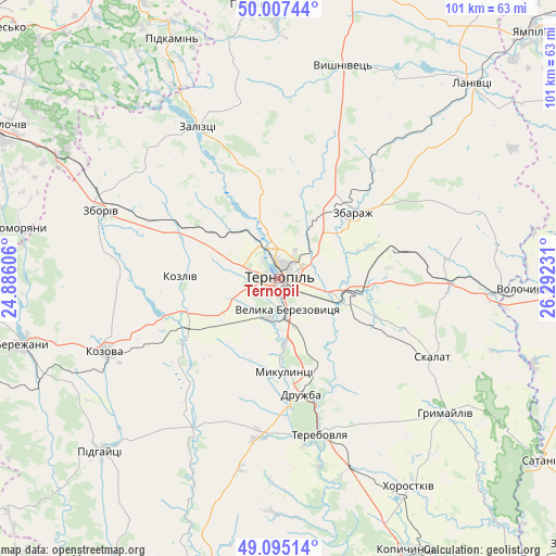
Ternopil GPS coordinates[2]
49° 33' 12.312" North, 25° 35' 21.048" East
| Map corner | latitude | longitude |
|---|---|---|
| Upper-left | 50.00744°, | 24.88606° |
| Center: | 49.55342°, | 25.58918° |
| Lower-right: | 49.09514°, | 26.29231° |
| Map W x H: | 101.4×101.4 km | = 63×63mi |
| max Lat: | 52.18903° ⇑24.4% North |
| Ternopil: | 49.55342° |
| min Lat: | ⇓75.6% South 44.39214° |
| min Long | Ternopil | max Long |
| 22.20555° | 25.58918° | 40.13222° |
| W 16.8%⇐ | ⇒83.2% E |
Elevation
Elevation of Ternopil is 317 m = 1040 ft, and this is 161.2 m = 529 ft above average elevation for this country.
| Max E: |
886 m = 2907 ft | 8.6% |
| Ternopil | 317 m 1040 ft | |
| Avg. | 155.8 m = 511 ft | |
Min E: |
-3 m = -10 ft | 91.4% |
See also: Ternopil elevation on elevation.city.
Geographical zone
Ternopil is located in North temperate zone (between Tropic of Cancer and the Arctic Circle). Distance of this North polar circle is 1891.4 km =1175.3 mi to North.| Distance of | km | miles | from Ternopil |
|---|---|---|---|
| North Pole | 4497.2 | 2794.4 | to North |
| Arctic Circle | 1891.4 | 1175.3 | to North |
| Tropic Cancer | 2903.9 | 1804.4 | to South |
| Equator | 5509.8 | 3423.6 | to South |


Nearby cities:
15 places around Ternopil: (largest is in red/bold)
• Hrymayliv
39.2 km =24.4 mi,  128°
128°
• Khorostkiv
45 km =28 mi,  147°
147°
• Kozova
34.3 km =21.3 mi,  247°
247°
• Mikulintsy
17.5 km =10.9 mi,  176°
176°
• Nadrichne
45.5 km =28.3 mi,  267°
267°
• Ozerna
20.5 km =12.7 mi,  294°
294°
• Petrikov
2.6 km =1.6 mi,  196°
196°
• Pidvolochysk
40.2 km =25 mi,  92°
92°
• Skalat
31.4 km =19.5 mi,  116°
116°
• Terebovlya
29.3 km =18.2 mi,  162°
162°
• Velikiye Borki
12.6 km =7.8 mi,  105°
105°
• Volochysk
45.2 km =28.1 mi, 92°
• Zaliztsi
30.7 km =19.1 mi,  329°
329°
• Zbarazh
18.2 km =11.3 mi,  47°
47°
• Zboriv
34.6 km =21.5 mi, 290°
Sources, notices
• [Note1] Compared only with cities in Ukraine existing in our database
• [Src1] Map data: © OpenStreetMap contributors (CC-BY-SA)
• [Src2] Other city data from geonames.org with taken over terms of usage.
• [Src3] Geographical zone / Annual Mean Temperature by Robert A. Rohde @ Wikipedia
