Mikulintsy geodata
Mikulintsy (Ternopil) is a populated place; located in Ukraine in Europe/Kiev (GMT+3) time zone. With population of 3,457 people, there are 841 cities with bigger population in this country. Compared to other cities in Ukraine, 72.7% of cities are located further ↓South; 83.1% of cities are located further →East and 87.7% of cities have lower elevation than Mikulintsy. Note1


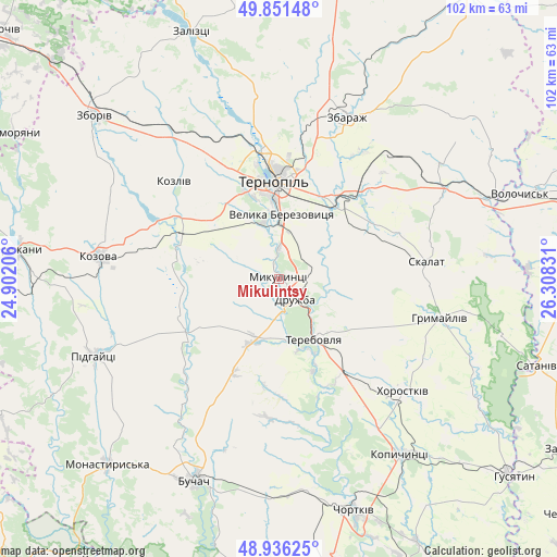
Mikulintsy GPS coordinates[2]
49° 23' 45.6" North, 25° 36' 18.648" East
| Map corner | latitude | longitude |
|---|---|---|
| Upper-left | 49.85148°, | 24.90206° |
| Center: | 49.396°, | 25.60518° |
| Lower-right: | 48.93625°, | 26.30831° |
| Map W x H: | 101.8×101.8 km | = 63.3×63.3mi |
| max Lat: | 52.18903° ⇑27.3% North |
| Mikulintsy: | 49.396° |
| min Lat: | ⇓72.7% South 44.39214° |
| min Long | Mikulintsy | max Long |
| 22.20555° | 25.60518° | 40.13222° |
| W 16.9%⇐ | ⇒83.1% E |
Elevation
Elevation of Mikulintsy is 292 m = 958 ft, and this is 136.2 m = 447 ft above average elevation for this country.
| Max E: |
886 m = 2907 ft | 12.3% |
| Mikulintsy | 292 m 958 ft | |
| Avg. | 155.8 m = 511 ft | |
Min E: |
-3 m = -10 ft | 87.7% |
See also: Ukraine elevation on elevation.city.
Geographical zone
Mikulintsy is located in North temperate zone (between Tropic of Cancer and the Arctic Circle). Distance of this North polar circle is 1908.9 km =1186.1 mi to North.| Distance of | km | miles | from Mikulintsy |
|---|---|---|---|
| North Pole | 4514.7 | 2805.3 | to North |
| Arctic Circle | 1908.9 | 1186.1 | to North |
| Tropic Cancer | 2886.4 | 1793.5 | to South |
| Equator | 5492.3 | 3412.8 | to South |


Nearby cities:
15 places around Mikulintsy: (largest is in red/bold)
• Buchach
40.3 km =25 mi,  203°
203°
• Druzhba
40.9 km =25.4 mi, 195°
• Hrymayliv
30.2 km =18.8 mi,  103°
103°
• Khorostkiv
30.8 km =19.1 mi,  131°
131°
• Kopychyntsi
39.3 km =24.4 mi,  145°
145°
• Kozova
33.2 km =20.6 mi,  277°
277°
• Ozerna
32.7 km =20.3 mi,  322°
322°
• Petrikov
15.2 km =9.4 mi,  352°
352°
• Pidhaytsi
37 km =23 mi,  247°
247°
• Pidvolochysk
42 km =26.1 mi,  68°
68°
• Skalat
27.2 km =16.9 mi,  82°
82°
• Terebovlya
12.9 km =8 mi,  144°
144°
• Ternopil
17.5 km =10.9 mi,  356°
356°
• Velikiye Borki
18 km =11.2 mi,  37°
37°
• Zbarazh
32.2 km =20 mi,  22°
22°
Sources, notices
• [Note1] Compared only with cities in Ukraine existing in our database
• [Src1] Map data: © OpenStreetMap contributors (CC-BY-SA)
• [Src2] Other city data from geonames.org with taken over terms of usage.
• [Src3] Geographical zone / Annual Mean Temperature by Robert A. Rohde @ Wikipedia
