Zbarazh geodata
Zbarazh (Ternopil) is a seat of a second-order administrative division; located in Ukraine in Europe/Kiev (GMT+3) time zone. With population of 12,736 people, there are 290 cities with bigger population in this country. Compared to other cities in Ukraine, 77.2% of cities are located further ↓South; 81.7% of cities are located further →East and 91.4% of cities have lower elevation than Zbarazh. Note1


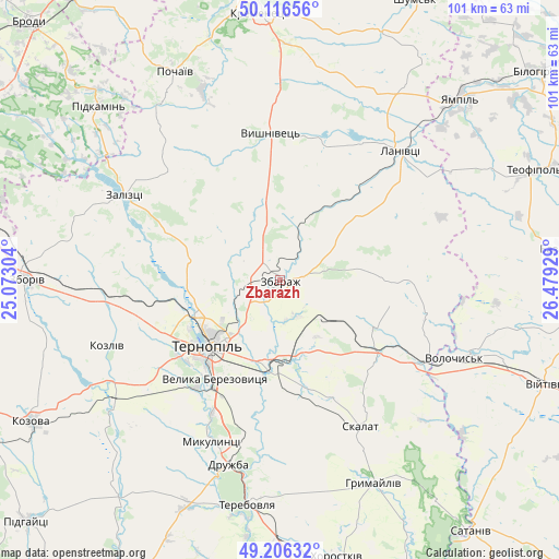
Zbarazh GPS coordinates[2]
49° 39' 48.852" North, 25° 46' 34.176" East
| Map corner | latitude | longitude |
|---|---|---|
| Upper-left | 50.11656°, | 25.07304° |
| Center: | 49.66357°, | 25.77616° |
| Lower-right: | 49.20632°, | 26.47929° |
| Map W x H: | 101.2×101.2 km | = 62.9×62.9mi |
| max Lat: | 52.18903° ⇑22.8% North |
| Zbarazh: | 49.66357° |
| min Lat: | ⇓77.2% South 44.39214° |
| min Long | Zbarazh | max Long |
| 22.20555° | 25.77616° | 40.13222° |
| W 18.3%⇐ | ⇒81.7% E |
Elevation
Elevation of Zbarazh is 317 m = 1040 ft, and this is 161.2 m = 529 ft above average elevation for this country.
| Max E: |
886 m = 2907 ft | 8.6% |
| Zbarazh | 317 m 1040 ft | |
| Avg. | 155.8 m = 511 ft | |
Min E: |
-3 m = -10 ft | 91.4% |
See also: Ukraine elevation on elevation.city.
Geographical zone
Zbarazh is located in North temperate zone (between Tropic of Cancer and the Arctic Circle). Distance of this North polar circle is 1879.1 km =1167.6 mi to North.| Distance of | km | miles | from Zbarazh |
|---|---|---|---|
| North Pole | 4485 | 2786.8 | to North |
| Arctic Circle | 1879.1 | 1167.6 | to North |
| Tropic Cancer | 2916.2 | 1812 | to South |
| Equator | 5522.1 | 3431.3 | to South |


Nearby cities:
15 places around Zbarazh: (largest is in red/bold)
• Hrymayliv
40.6 km =25.2 mi,  155°
155°
• Lanivtsi
31.7 km =19.7 mi,  45°
45°
• Mikulintsy
32.2 km =20 mi,  202°
202°
• Ozerna
32.4 km =20.1 mi,  263°
263°
• Petrikov
20.5 km =12.7 mi,  223°
223°
• Pidkamin’
45.5 km =28.3 mi,  313°
313°
• Pidvolochysk
30.2 km =18.8 mi,  118°
118°
• Pochaiv
42.4 km =26.3 mi,  333°
333°
• Skalat
30.1 km =18.7 mi,  150°
150°
• Terebovlya
40.5 km =25.2 mi,  186°
186°
• Ternopil
18.2 km =11.3 mi,  227°
227°
• Velikiye Borki
15.6 km =9.7 mi,  184°
184°
• Volochysk
34.6 km =21.5 mi,  113°
113°
• Zaliztsi
32.3 km =20.1 mi,  296°
296°
• Zboriv
45.7 km =28.4 mi,  270°
270°
Sources, notices
• [Note1] Compared only with cities in Ukraine existing in our database
• [Src1] Map data: © OpenStreetMap contributors (CC-BY-SA)
• [Src2] Other city data from geonames.org with taken over terms of usage.
• [Src3] Geographical zone / Annual Mean Temperature by Robert A. Rohde @ Wikipedia
