Sverdlovs’k geodata
Sverdlovs’k (Luhansk) is a seat of a second-order administrative division; located in Ukraine in Europe/Zaporozhye (GMT+3) time zone. With population of 68,000 people, there are 68 cities with bigger population in this country. Compared to other cities in Ukraine, 54.9% of cities are located further ↑North; 99.6% of cities are located further ←West and 84.5% of cities have lower elevation than Sverdlovs’k. Note1


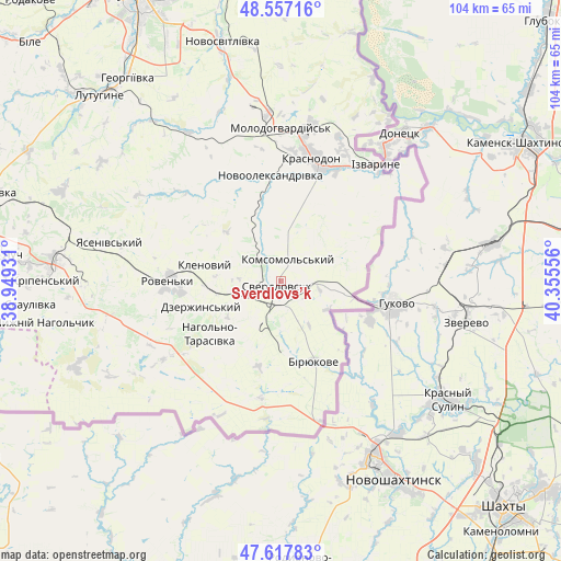
Sverdlovs’k GPS coordinates[2]
48° 5' 22.704" North, 39° 39' 8.748" East
| Map corner | latitude | longitude |
|---|---|---|
| Upper-left | 48.55716°, | 38.94931° |
| Center: | 48.08964°, | 39.65243° |
| Lower-right: | 47.61783°, | 40.35556° |
| Map W x H: | 104.4×104.4 km | = 64.9×64.9mi |
| max Lat: | 52.18903° ⇑54.9% North |
| Sverdlovs’k: | 48.08964° |
| min Lat: | ⇓45.1% South 44.39214° |
| min Long | Sverdlovs’k | max Long |
| 22.20555° | 39.65243° | 40.13222° |
| W 99.6%⇐ | ⇒0.40000000000001% E |
Elevation
Elevation of Sverdlovs’k is 271 m = 889 ft, and this is 115.2 m = 378 ft above average elevation for this country.
| Max E: |
886 m = 2907 ft | 15.5% |
| Sverdlovs’k | 271 m 889 ft | |
| Avg. | 155.8 m = 511 ft | |
Min E: |
-3 m = -10 ft | 84.5% |
See also: Sverdlovs’k elevation on elevation.city.
Geographical zone
Sverdlovs’k is located in North temperate zone (between Tropic of Cancer and the Arctic Circle). Distance of this North polar circle is 2054.1 km =1276.4 mi to North.| Distance of | km | miles | from Sverdlovs’k |
|---|---|---|---|
| North Pole | 4660 | 2895.6 | to North |
| Arctic Circle | 2054.1 | 1276.4 | to North |
| Tropic Cancer | 2741.1 | 1703.2 | to South |
| Equator | 5347.1 | 3322.5 | to South |


Nearby cities:
15 places around Sverdlovs’k: (largest is in red/bold)
• Antratsyt
41.8 km =26 mi,  273°
273°
• Biryukove
16.1 km =10 mi,  156°
156°
• Buran
23.6 km =14.7 mi,  353°
353°
• Chervonopartyzans’k
10.8 km =6.7 mi,  98°
98°
• Klenovyy
14.8 km =9.2 mi,  282°
282°
• Kripens’kyy
44.2 km =27.5 mi, 268°
• Lutuhyne
47.2 km =29.3 mi,  318°
318°
• Millerovo
37.2 km =23.1 mi, 283°
• Molodohvardiys’k
28.4 km =17.6 mi,  0°
0°
• Roven’ky
20.4 km =12.7 mi, 268°
• Simeykyne
27.8 km =17.3 mi,  341°
341°
• Sorokyne
23.4 km =14.5 mi,  15°
15°
• Teple
25.6 km =15.9 mi, 344°
• Uralo-Kavkaz
28.1 km =17.5 mi, 23°
• Uspenka
49.4 km =30.7 mi,  312°
312°
Sources, notices
• [Note1] Compared only with cities in Ukraine existing in our database
• [Src1] Map data: © OpenStreetMap contributors (CC-BY-SA)
• [Src2] Other city data from geonames.org with taken over terms of usage.
• [Src3] Geographical zone / Annual Mean Temperature by Robert A. Rohde @ Wikipedia
