Zhvanets geodata
Zhvanets (Khmelnytskyi) is a populated place; located in Ukraine in Europe/Kiev (GMT+3) time zone. With population of 1,529 people, there are 1203 cities with bigger population in this country. Compared to other cities in Ukraine, 56.7% of cities are located further ↓South; 79.3% of cities are located further →East and 57.2% of cities have lower elevation than Zhvanets. Note1


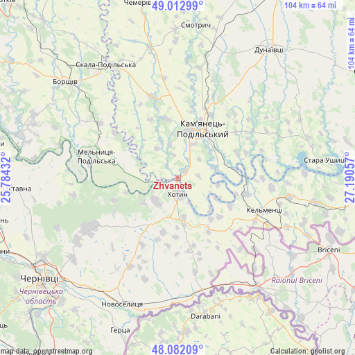
Zhvanets GPS coordinates[2]
48° 32' 58.848" North, 26° 29' 14.784" East
| Map corner | latitude | longitude |
|---|---|---|
| Upper-left | 49.01299°, | 25.78432° |
| Center: | 48.54968°, | 26.48744° |
| Lower-right: | 48.08209°, | 27.19057° |
| Map W x H: | 103.5×103.5 km | = 64.3×64.3mi |
| max Lat: | 52.18903° ⇑43.3% North |
| Zhvanets: | 48.54968° |
| min Lat: | ⇓56.7% South 44.39214° |
| min Long | Zhvanets | max Long |
| 22.20555° | 26.48744° | 40.13222° |
| W 20.7%⇐ | ⇒79.3% E |
Elevation
Elevation of Zhvanets is 159 m = 522 ft, and this is 3.2 m = 10 ft above average elevation for this country.
| Max E: |
886 m = 2907 ft | 42.8% |
| Zhvanets | 159 m 522 ft | |
| Avg. | 155.8 m = 511 ft | |
Min E: |
-3 m = -10 ft | 57.2% |
See also: Ukraine elevation on elevation.city.
Geographical zone
Zhvanets is located in North temperate zone (between Tropic of Cancer and the Arctic Circle). Distance of this North polar circle is 2003 km =1244.6 mi to North.| Distance of | km | miles | from Zhvanets |
|---|---|---|---|
| North Pole | 4608.8 | 2863.8 | to North |
| Arctic Circle | 2003 | 1244.6 | to North |
| Tropic Cancer | 2792.3 | 1735.1 | to South |
| Equator | 5398.2 | 3354.3 | to South |


Nearby cities:
15 places around Zhvanets: (largest is in red/bold)
• Borshchiv
43.1 km =26.8 mi,  310°
310°
• Boyany
40.9 km =25.4 mi,  220°
220°
• Chernivtsi
49.5 km =30.8 mi,  234°
234°
• Dunaivtsi
46.4 km =28.8 mi,  35°
35°
• Kamianets-Podilskyi
16.6 km =10.3 mi,  25°
25°
• Kel’mentsi
27.2 km =16.9 mi,  110°
110°
• Khotyn
4.8 km =3 mi,  176°
176°
• Klishkivtsi
21.2 km =13.2 mi, 231°
• Makiv
31.1 km =19.3 mi, 28°
• Marshintsy
39.7 km =24.7 mi,  201°
201°
• Molodiya
50 km =31.1 mi, 223°
• Novoselytsya
40.2 km =25 mi, 204°
• Skala-Podil’s’ka
39.7 km =24.7 mi,  327°
327°
• Smotrych
13.5 km =8.4 mi,  23°
23°
• Zastavna
47.5 km =29.5 mi,  266°
266°
Sources, notices
• [Note1] Compared only with cities in Ukraine existing in our database
• [Src1] Map data: © OpenStreetMap contributors (CC-BY-SA)
• [Src2] Other city data from geonames.org with taken over terms of usage.
• [Src3] Geographical zone / Annual Mean Temperature by Robert A. Rohde @ Wikipedia
