Sharhorod geodata
Sharhorod (Vinnyts'ka) is a seat of a second-order administrative division; located in Ukraine in Europe/Kiev (GMT+3) time zone. With population of 6,895 people, there are 516 cities with bigger population in this country. Compared to other cities in Ukraine, 61.5% of cities are located further ↓South; 75.7% of cities are located further →East and 84.5% of cities have lower elevation than Sharhorod. Note1


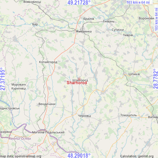
Sharhorod GPS coordinates[2]
48° 45' 21.132" North, 28° 4' 30.252" East
| Map corner | latitude | longitude |
|---|---|---|
| Upper-left | 49.21728°, | 27.37195° |
| Center: | 48.75587°, | 28.07507° |
| Lower-right: | 48.29018°, | 28.7782° |
| Map W x H: | 103.1×103.1 km | = 64.1×64.1mi |
| max Lat: | 52.18903° ⇑38.5% North |
| Sharhorod: | 48.75587° |
| min Lat: | ⇓61.5% South 44.39214° |
| min Long | Sharhorod | max Long |
| 22.20555° | 28.07507° | 40.13222° |
| W 24.3%⇐ | ⇒75.7% E |
Elevation
Elevation of Sharhorod is 271 m = 889 ft, and this is 115.2 m = 378 ft above average elevation for this country.
| Max E: |
886 m = 2907 ft | 15.5% |
| Sharhorod | 271 m 889 ft | |
| Avg. | 155.8 m = 511 ft | |
Min E: |
-3 m = -10 ft | 84.5% |
See also: Ukraine elevation on elevation.city.
Geographical zone
Sharhorod is located in North temperate zone (between Tropic of Cancer and the Arctic Circle). Distance of this North polar circle is 1980 km =1230.3 mi to North.| Distance of | km | miles | from Sharhorod |
|---|---|---|---|
| North Pole | 4585.9 | 2849.5 | to North |
| Arctic Circle | 1980 | 1230.3 | to North |
| Tropic Cancer | 2815.2 | 1749.3 | to South |
| Equator | 5421.1 | 3368.5 | to South |


Nearby cities:
15 places around Sharhorod: (largest is in red/bold)
• Bar
45.8 km =28.5 mi,  321°
321°
• Brailiv
40 km =24.9 mi,  10°
10°
• Chernivtsi
23.9 km =14.9 mi,  173°
173°
• Klembivka
47.6 km =29.6 mi,  148°
148°
• Kopayhorod
23.4 km =14.5 mi,  299°
299°
• Mohyliv-Podilskyi
40 km =24.9 mi,  210°
210°
• Murafa
10.4 km =6.5 mi,  82°
82°
• Murovani Kurylivtsi
40.9 km =25.4 mi,  264°
264°
• Novodnistrovs’k
50.4 km =31.3 mi,  247°
247°
• Serebriya
42.4 km =26.3 mi,  218°
218°
• Sutysky
40.5 km =25.2 mi,  38°
38°
• Tomashpil’
40.2 km =25 mi,  126°
126°
• Tyvriv
42.8 km =26.6 mi,  47°
47°
• Vendychany
26.2 km =16.3 mi,  232°
232°
• Zhmerynka
31.4 km =19.5 mi,  4°
4°
Sources, notices
• [Note1] Compared only with cities in Ukraine existing in our database
• [Src1] Map data: © OpenStreetMap contributors (CC-BY-SA)
• [Src2] Other city data from geonames.org with taken over terms of usage.
• [Src3] Geographical zone / Annual Mean Temperature by Robert A. Rohde @ Wikipedia
