Vendychany geodata
Vendychany (Vinnyts'ka) is a populated place; located in Ukraine in Europe/Kiev (GMT+3) time zone. With population of 4,182 people, there are 740 cities with bigger population in this country. Compared to other cities in Ukraine, 58% of cities are located further ↓South; 76.4% of cities are located further →East and 77.1% of cities have lower elevation than Vendychany. Note1


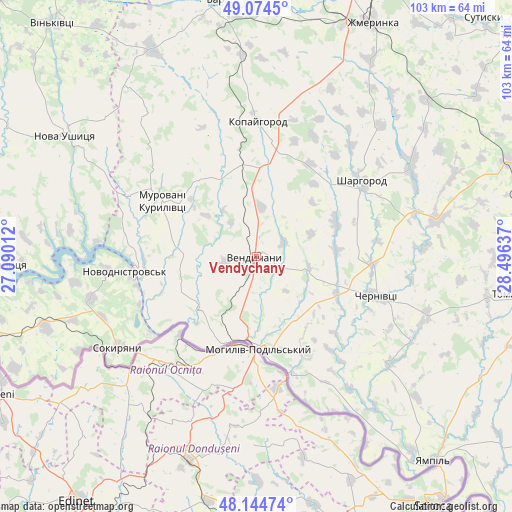
Vendychany GPS coordinates[2]
48° 36' 42.336" North, 27° 47' 35.664" East
| Map corner | latitude | longitude |
|---|---|---|
| Upper-left | 49.0745°, | 27.09012° |
| Center: | 48.61176°, | 27.79324° |
| Lower-right: | 48.14474°, | 28.49637° |
| Map W x H: | 103.4×103.4 km | = 64.2×64.2mi |
| max Lat: | 52.18903° ⇑42% North |
| Vendychany: | 48.61176° |
| min Lat: | ⇓58% South 44.39214° |
| min Long | Vendychany | max Long |
| 22.20555° | 27.79324° | 40.13222° |
| W 23.6%⇐ | ⇒76.4% E |
Elevation
Elevation of Vendychany is 234 m = 768 ft, and this is 78.2 m = 257 ft above average elevation for this country.
| Max E: |
886 m = 2907 ft | 22.9% |
| Vendychany | 234 m 768 ft | |
| Avg. | 155.8 m = 511 ft | |
Min E: |
-3 m = -10 ft | 77.1% |
See also: Ukraine elevation on elevation.city.
Geographical zone
Vendychany is located in North temperate zone (between Tropic of Cancer and the Arctic Circle). Distance of this North polar circle is 1996.1 km =1240.3 mi to North.| Distance of | km | miles | from Vendychany |
|---|---|---|---|
| North Pole | 4601.9 | 2859.5 | to North |
| Arctic Circle | 1996.1 | 1240.3 | to North |
| Tropic Cancer | 2799.2 | 1739.3 | to South |
| Equator | 5405.1 | 3358.6 | to South |


Nearby cities:
15 places around Vendychany: (largest is in red/bold)
• Bar
52.4 km =32.6 mi,  351°
351°
• Chernivtsi
24.9 km =15.5 mi,  108°
108°
• Klembivka
51.7 km =32.1 mi,  118°
118°
• Kopayhorod
27.5 km =17.1 mi,  0°
0°
• Mohyliv-Podilskyi
18.4 km =11.4 mi,  178°
178°
• Murafa
35.5 km =22.1 mi,  60°
60°
• Murovani Kurylivtsi
23.7 km =14.7 mi,  301°
301°
• Nova Ushytsya
45.6 km =28.3 mi, 303°
• Novodnistrovs’k
26.1 km =16.2 mi,  262°
262°
• Serebriya
18.2 km =11.3 mi,  197°
197°
• Sharhorod
26.2 km =16.3 mi,  52°
52°
• Sokyryany
33.2 km =20.6 mi,  236°
236°
• Tomashpil’
53.8 km =33.4 mi,  98°
98°
• Yampil’
54.7 km =34 mi,  138°
138°
• Zhmerynka
52.7 km =32.7 mi,  26°
26°
Sources, notices
• [Note1] Compared only with cities in Ukraine existing in our database
• [Src1] Map data: © OpenStreetMap contributors (CC-BY-SA)
• [Src2] Other city data from geonames.org with taken over terms of usage.
• [Src3] Geographical zone / Annual Mean Temperature by Robert A. Rohde @ Wikipedia
