Selydove geodata
Selydove (Donetsk) is a populated place; located in Ukraine in Europe/Kiev (GMT+3) time zone. With population of 24,269 people, there are 170 cities with bigger population in this country. Compared to other cities in Ukraine, 53.5% of cities are located further ↑North; 91.8% of cities are located further ←West and 59.6% of cities have lower elevation than Selydove. Note1


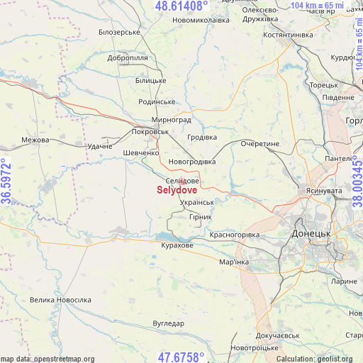
Selydove GPS coordinates[2]
48° 8' 49.488" North, 37° 18' 1.152" East
| Map corner | latitude | longitude |
|---|---|---|
| Upper-left | 48.61408°, | 36.5972° |
| Center: | 48.14708°, | 37.30032° |
| Lower-right: | 47.6758°, | 38.00345° |
| Map W x H: | 104.3×104.3 km | = 64.8×64.8mi |
| max Lat: | 52.18903° ⇑53.5% North |
| Selydove: | 48.14708° |
| min Lat: | ⇓46.5% South 44.39214° |
| min Long | Selydove | max Long |
| 22.20555° | 37.30032° | 40.13222° |
| W 91.8%⇐ | ⇒8.2% E |
Elevation
Elevation of Selydove is 167 m = 548 ft, and this is 11.2 m = 37 ft above average elevation for this country.
| Max E: |
886 m = 2907 ft | 40.4% |
| Selydove | 167 m 548 ft | |
| Avg. | 155.8 m = 511 ft | |
Min E: |
-3 m = -10 ft | 59.6% |
See also: Ukraine elevation on elevation.city.
Geographical zone
Selydove is located in North temperate zone (between Tropic of Cancer and the Arctic Circle). Distance of this North polar circle is 2047.7 km =1272.4 mi to North.| Distance of | km | miles | from Selydove |
|---|---|---|---|
| North Pole | 4653.6 | 2891.6 | to North |
| Arctic Circle | 2047.7 | 1272.4 | to North |
| Tropic Cancer | 2747.5 | 1707.2 | to South |
| Equator | 5353.5 | 3326.5 | to South |


Nearby cities:
15 places around Selydove: (largest is in red/bold)
• Avdiyivka
32.8 km =20.4 mi,  91°
91°
• Bilyts’ke
30.2 km =18.8 mi,  342°
342°
• Dobropillya
38.4 km =23.9 mi, 335°
• Donetsk
39.8 km =24.7 mi,  110°
110°
• Kurakhovo
18 km =11.2 mi,  184°
184°
• Makiyivka
47.7 km =29.6 mi,  103°
103°
• Mar'yinka
27.1 km =16.8 mi,  145°
145°
• Mezhova
43.5 km =27 mi,  285°
285°
• Myrnohrad
17.8 km =11.1 mi,  350°
350°
• Pokrovsk
17.6 km =10.9 mi,  328°
328°
• Rodyns’ke
23.8 km =14.8 mi, 342°
• Shcherbynivka
45.6 km =28.3 mi,  52°
52°
• Toretsk
49.2 km =30.6 mi,  55°
55°
• Velyka Novosilka
48.2 km =30 mi,  225°
225°
• Yasynuvata
41.5 km =25.8 mi, 92°
Sources, notices
• [Note1] Compared only with cities in Ukraine existing in our database
• [Src1] Map data: © OpenStreetMap contributors (CC-BY-SA)
• [Src2] Other city data from geonames.org with taken over terms of usage.
• [Src3] Geographical zone / Annual Mean Temperature by Robert A. Rohde @ Wikipedia
