Mar'yinka geodata
Mar'yinka (Donetsk) is a seat of a second-order administrative division; located in Ukraine in Europe/Kiev (GMT+3) time zone. With population of 9,900 people, there are 365 cities with bigger population in this country. Compared to other cities in Ukraine, 57.3% of cities are located further ↑North; 92.5% of cities are located further ←West and 50.9% of cities have lower elevation than Mar'yinka. Note1


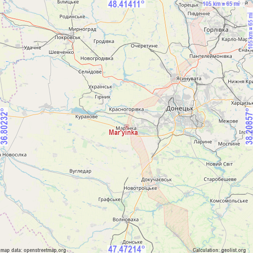
Mar'yinka GPS coordinates[2]
47° 56' 42.972" North, 37° 30' 19.584" East
| Map corner | latitude | longitude |
|---|---|---|
| Upper-left | 48.41411°, | 36.80232° |
| Center: | 47.94527°, | 37.50544° |
| Lower-right: | 47.47214°, | 38.20857° |
| Map W x H: | 104.7×104.7 km | = 65.1×65.1mi |
| max Lat: | 52.18903° ⇑57.3% North |
| Mar'yinka: | 47.94527° |
| min Lat: | ⇓42.7% South 44.39214° |
| min Long | Mar'yinka | max Long |
| 22.20555° | 37.50544° | 40.13222° |
| W 92.5%⇐ | ⇒7.5% E |
Elevation
Elevation of Mar'yinka is 139 m = 456 ft, and this is 16.8 m = 55 ft below average elevation for this country.
| Max E: |
886 m = 2907 ft | 49.1% |
| Avg. | 155.8 m = 511 ft | |
| Mar'yinka | 139 m = 456 ft | |
Min E: |
-3 m = -10 ft | 50.9% |
See also: Ukraine elevation on elevation.city.
Geographical zone
Mar'yinka is located in North temperate zone (between Tropic of Cancer and the Arctic Circle). Distance of this North polar circle is 2070.2 km =1286.4 mi to North.| Distance of | km | miles | from Mar'yinka |
|---|---|---|---|
| North Pole | 4676 | 2905.5 | to North |
| Arctic Circle | 2070.2 | 1286.4 | to North |
| Tropic Cancer | 2725.1 | 1693.3 | to South |
| Equator | 5331 | 3312.5 | to South |


Nearby cities:
15 places around Mar'yinka: (largest is in red/bold)
• Avdiyivka
27.9 km =17.3 mi,  39°
39°
• Blahodatne
28 km =17.4 mi,  193°
193°
• Dokuchayevs’k
25.3 km =15.7 mi,  149°
149°
• Donetsk
23.7 km =14.7 mi,  68°
68°
• Horbachevo-Mykhaylivka
38.8 km =24.1 mi,  105°
105°
• Krinichnaya
43.8 km =27.2 mi,  62°
62°
• Kurakhovo
17.2 km =10.7 mi,  284°
284°
• Makiyivka
33.3 km =20.7 mi, 69°
• Mospyne
42.1 km =26.2 mi,  98°
98°
• Myrnohrad
43.9 km =27.3 mi,  335°
335°
• Novyy Svit
41.5 km =25.8 mi, 111°
• Selydove
27.1 km =16.8 mi,  325°
325°
• Volnovakha
38.3 km =23.8 mi,  180°
180°
• Vysoke
41.2 km =25.6 mi,  90°
90°
• Yasynuvata
33.4 km =20.8 mi,  52°
52°
Sources, notices
• [Note1] Compared only with cities in Ukraine existing in our database
• [Src1] Map data: © OpenStreetMap contributors (CC-BY-SA)
• [Src2] Other city data from geonames.org with taken over terms of usage.
• [Src3] Geographical zone / Annual Mean Temperature by Robert A. Rohde @ Wikipedia
