Rodyns’ke geodata
Rodyns’ke (Donetsk) is a populated place; located in Ukraine in Europe/Kiev (GMT+3) time zone. With population of 11,550 people, there are 317 cities with bigger population in this country. Compared to other cities in Ukraine, 51.4% of cities are located further ↓South; 91.5% of cities are located further ←West and 66.5% of cities have lower elevation than Rodyns’ke. Note1


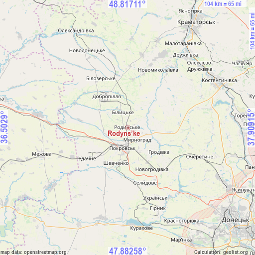
Rodyns’ke GPS coordinates[2]
48° 21' 7.164" North, 37° 12' 21.672" East
| Map corner | latitude | longitude |
|---|---|---|
| Upper-left | 48.81711°, | 36.5029° |
| Center: | 48.35199°, | 37.20602° |
| Lower-right: | 47.88258°, | 37.90915° |
| Map W x H: | 103.9×103.9 km | = 64.6×64.6mi |
| max Lat: | 52.18903° ⇑48.6% North |
| Rodyns’ke: | 48.35199° |
| min Lat: | ⇓51.4% South 44.39214° |
| min Long | Rodyns’ke | max Long |
| 22.20555° | 37.20602° | 40.13222° |
| W 91.5%⇐ | ⇒8.5% E |
Elevation
Elevation of Rodyns’ke is 192 m = 630 ft, and this is 36.2 m = 119 ft above average elevation for this country.
| Max E: |
886 m = 2907 ft | 33.5% |
| Rodyns’ke | 192 m 630 ft | |
| Avg. | 155.8 m = 511 ft | |
Min E: |
-3 m = -10 ft | 66.5% |
See also: Ukraine elevation on elevation.city.
Geographical zone
Rodyns’ke is located in North temperate zone (between Tropic of Cancer and the Arctic Circle). Distance of this North polar circle is 2024.9 km =1258.2 mi to North.| Distance of | km | miles | from Rodyns’ke |
|---|---|---|---|
| North Pole | 4630.8 | 2877.4 | to North |
| Arctic Circle | 2024.9 | 1258.2 | to North |
| Tropic Cancer | 2770.3 | 1721.4 | to South |
| Equator | 5376.2 | 3340.6 | to South |


Nearby cities:
15 places around Rodyns’ke: (largest is in red/bold)
• Avdiyivka
46.2 km =28.7 mi,  120°
120°
• Bilyts’ke
6.3 km =3.9 mi,  343°
343°
• Dobropillya
15.1 km =9.4 mi,  323°
323°
• Druzhkivka
40.1 km =24.9 mi,  39°
39°
• Kostyantynivka
41.8 km =26 mi,  62°
62°
• Krasnotorka
43.9 km =27.3 mi,  33°
33°
• Kurakhovo
41.2 km =25.6 mi,  172°
172°
• Mezhova
36.6 km =22.7 mi,  252°
252°
• Myrnohrad
6.6 km =4.1 mi,  142°
142°
• Novodonets’ke
35.5 km =22.1 mi,  332°
332°
• Oleksandrivka
45 km =28 mi, 331°
• Pokrovsk
8.1 km =5 mi,  195°
195°
• Selydove
23.8 km =14.8 mi,  162°
162°
• Shcherbynivka
43.5 km =27 mi,  83°
83°
• Toretsk
47.7 km =29.6 mi, 83°
Sources, notices
• [Note1] Compared only with cities in Ukraine existing in our database
• [Src1] Map data: © OpenStreetMap contributors (CC-BY-SA)
• [Src2] Other city data from geonames.org with taken over terms of usage.
• [Src3] Geographical zone / Annual Mean Temperature by Robert A. Rohde @ Wikipedia
