Myrnohrad geodata
Myrnohrad (Donetsk) is a seat of a second-order administrative division; located in Ukraine in Europe/Kiev (GMT+3) time zone. With population of 49,646 people, there are 98 cities with bigger population in this country. Compared to other cities in Ukraine, 50% of cities are located further ↓South; 91.6% of cities are located further ←West and 62.9% of cities have lower elevation than Myrnohrad. Note1


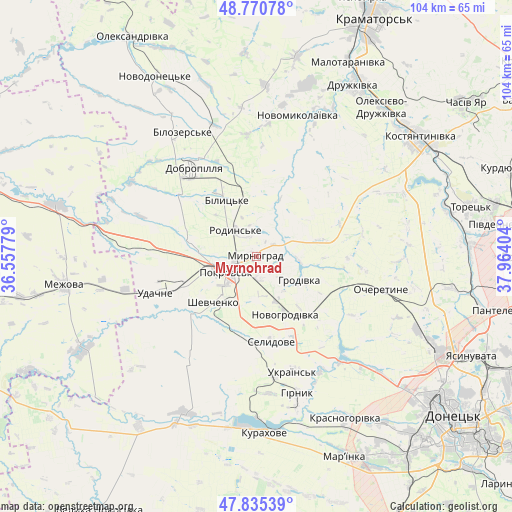
Myrnohrad GPS coordinates[2]
48° 18' 18.828" North, 37° 15' 39.276" East
| Map corner | latitude | longitude |
|---|---|---|
| Upper-left | 48.77078°, | 36.55779° |
| Center: | 48.30523°, | 37.26091° |
| Lower-right: | 47.83539°, | 37.96404° |
| Map W x H: | 104×104 km | = 64.6×64.6mi |
| max Lat: | 52.18903° ⇑50% North |
| Myrnohrad: | 48.30523° |
| min Lat: | ⇓50% South 44.39214° |
| min Long | Myrnohrad | max Long |
| 22.20555° | 37.26091° | 40.13222° |
| W 91.6%⇐ | ⇒8.4% E |
Elevation
Elevation of Myrnohrad is 179 m = 587 ft, and this is 23.2 m = 76 ft above average elevation for this country.
| Max E: |
886 m = 2907 ft | 37.1% |
| Myrnohrad | 179 m 587 ft | |
| Avg. | 155.8 m = 511 ft | |
Min E: |
-3 m = -10 ft | 62.9% |
See also: Myrnohrad elevation on elevation.city.
Geographical zone
Myrnohrad is located in North temperate zone (between Tropic of Cancer and the Arctic Circle). Distance of this North polar circle is 2030.1 km =1261.4 mi to North.| Distance of | km | miles | from Myrnohrad |
|---|---|---|---|
| North Pole | 4636 | 2880.7 | to North |
| Arctic Circle | 2030.1 | 1261.4 | to North |
| Tropic Cancer | 2765.1 | 1718.2 | to South |
| Equator | 5371 | 3337.4 | to South |


Nearby cities:
15 places around Myrnohrad: (largest is in red/bold)
• Avdiyivka
40.1 km =24.9 mi,  117°
117°
• Bilyts’ke
12.7 km =7.9 mi,  332°
332°
• Dobropillya
21.7 km =13.5 mi,  323°
323°
• Druzhkivka
42 km =26.1 mi,  30°
30°
• Kostyantynivka
41.2 km =25.6 mi,  53°
53°
• Krasnotorka
46.4 km =28.8 mi, 25°
• Kurakhovo
35.6 km =22.1 mi,  177°
177°
• Mar'yinka
43.9 km =27.3 mi,  155°
155°
• Mezhova
39.4 km =24.5 mi,  261°
261°
• Novodonets’ke
42 km =26.1 mi, 330°
• Pokrovsk
6.8 km =4.2 mi,  247°
247°
• Rodyns’ke
6.6 km =4.1 mi, 322°
• Selydove
17.8 km =11.1 mi,  170°
170°
• Shcherbynivka
40.4 km =25.1 mi,  75°
75°
• Toretsk
44.6 km =27.7 mi, 76°
In other languages:
- In German: Dymytrow
- In Russian: Dimitrovo, Мирноград, Dimitrov
- In Chinese: 季米特洛夫, 米爾諾格勒
Sources, notices
• [Note1] Compared only with cities in Ukraine existing in our database
• [Src1] Map data: © OpenStreetMap contributors (CC-BY-SA)
• [Src2] Other city data from geonames.org with taken over terms of usage.
• [Src3] Geographical zone / Annual Mean Temperature by Robert A. Rohde @ Wikipedia
