Poninka geodata
Poninka (Khmelnytskyi) is a populated place; located in Ukraine in Europe/Kiev (GMT+3) time zone. With population of 7,642 people, there are 469 cities with bigger population in this country. Compared to other cities in Ukraine, 86.3% of cities are located further ↓South; 77% of cities are located further →East and 78% of cities have lower elevation than Poninka. Note1


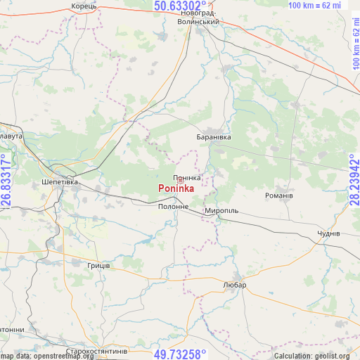
Poninka GPS coordinates[2]
50° 11' 5.712" North, 27° 32' 10.644" East
| Map corner | latitude | longitude |
|---|---|---|
| Upper-left | 50.63302°, | 26.83317° |
| Center: | 50.18492°, | 27.53629° |
| Lower-right: | 49.73258°, | 28.23942° |
| Map W x H: | 100.1×100.1 km | = 62.2×62.2mi |
| max Lat: | 52.18903° ⇑13.7% North |
| Poninka: | 50.18492° |
| min Lat: | ⇓86.3% South 44.39214° |
| min Long | Poninka | max Long |
| 22.20555° | 27.53629° | 40.13222° |
| W 23%⇐ | ⇒77% E |
Elevation
Elevation of Poninka is 239 m = 784 ft, and this is 83.2 m = 273 ft above average elevation for this country.
| Max E: |
886 m = 2907 ft | 22% |
| Poninka | 239 m 784 ft | |
| Avg. | 155.8 m = 511 ft | |
Min E: |
-3 m = -10 ft | 78% |
See also: Ukraine elevation on elevation.city.
Geographical zone
Poninka is located in North temperate zone (between Tropic of Cancer and the Arctic Circle). Distance of this North polar circle is 1821.1 km =1131.6 mi to North.| Distance of | km | miles | from Poninka |
|---|---|---|---|
| North Pole | 4427 | 2750.8 | to North |
| Arctic Circle | 1821.1 | 1131.6 | to North |
| Tropic Cancer | 2974.1 | 1848 | to South |
| Equator | 5580 | 3467.3 | to South |


Nearby cities:
15 places around Poninka: (largest is in red/bold)
• Baranivka
15.3 km =9.5 mi,  35°
35°
• Bykivka
34 km =21.1 mi,  69°
69°
• Chudniv
44 km =27.3 mi,  109°
109°
• Dovbysh
38.3 km =23.8 mi,  56°
56°
• Izyaslav
51.5 km =32 mi,  261°
261°
• Korets
54.9 km =34.1 mi,  330°
330°
• Liubar
33.4 km =20.8 mi,  151°
151°
• Novohrad-Volynskyi
45.9 km =28.5 mi,  7°
7°
• Novoselytsya
12.8 km =8 mi,  185°
185°
• Polonne
7 km =4.3 mi,  195°
195°
• Polyanka
13.5 km =8.4 mi,  52°
52°
• Romaniv
28.4 km =17.6 mi,  98°
98°
• Shepetivka
33.6 km =20.9 mi,  270°
270°
• Slavuta
49.5 km =30.8 mi,  285°
285°
• Starokostiantyniv
53.1 km =33 mi,  206°
206°
Sources, notices
• [Note1] Compared only with cities in Ukraine existing in our database
• [Src1] Map data: © OpenStreetMap contributors (CC-BY-SA)
• [Src2] Other city data from geonames.org with taken over terms of usage.
• [Src3] Geographical zone / Annual Mean Temperature by Robert A. Rohde @ Wikipedia
