Polyanka geodata
Polyanka (Zhytomyr) is a populated place; located in Ukraine in Europe/Kiev (GMT+3) time zone. With population of 1,693 people, there are 1172 cities with bigger population in this country. Compared to other cities in Ukraine, 87.3% of cities are located further ↓South; 76.5% of cities are located further →East and 73.1% of cities have lower elevation than Polyanka. Note1


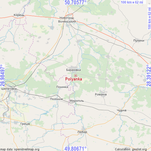
Polyanka GPS coordinates[2]
50° 15' 30.096" North, 27° 41' 17.124" East
| Map corner | latitude | longitude |
|---|---|---|
| Upper-left | 50.70577°, | 26.98497° |
| Center: | 50.25836°, | 27.68809° |
| Lower-right: | 49.80671°, | 28.39122° |
| Map W x H: | 100×100 km | = 62.1×62.1mi |
| max Lat: | 52.18903° ⇑12.7% North |
| Polyanka: | 50.25836° |
| min Lat: | ⇓87.3% South 44.39214° |
| min Long | Polyanka | max Long |
| 22.20555° | 27.68809° | 40.13222° |
| W 23.5%⇐ | ⇒76.5% E |
Elevation
Elevation of Polyanka is 217 m = 712 ft, and this is 61.2 m = 201 ft above average elevation for this country.
| Max E: |
886 m = 2907 ft | 26.9% |
| Polyanka | 217 m 712 ft | |
| Avg. | 155.8 m = 511 ft | |
Min E: |
-3 m = -10 ft | 73.1% |
See also: Ukraine elevation on elevation.city.
Geographical zone
Polyanka is located in North temperate zone (between Tropic of Cancer and the Arctic Circle). Distance of this North polar circle is 1813 km =1126.5 mi to North.| Distance of | km | miles | from Polyanka |
|---|---|---|---|
| North Pole | 4418.9 | 2745.8 | to North |
| Arctic Circle | 1813 | 1126.5 | to North |
| Tropic Cancer | 2982.3 | 1853.1 | to South |
| Equator | 5588.2 | 3472.3 | to South |


Nearby cities:
15 places around Polyanka: (largest is in red/bold)
• Baranivka
4.7 km =2.9 mi,  336°
336°
• Bykivka
21.3 km =13.2 mi,  79°
79°
• Chudniv
38.2 km =23.7 mi,  126°
126°
• Denyshi
51.1 km =31.8 mi,  95°
95°
• Dovbysh
24.8 km =15.4 mi,  58°
58°
• Korets
54.6 km =33.9 mi,  316°
316°
• Liubar
37.9 km =23.5 mi,  172°
172°
• Novohrad-Volynskyi
37.7 km =23.4 mi,  352°
352°
• Novoselytsya
24.1 km =15 mi,  209°
209°
• Polonne
19.5 km =12.1 mi,  220°
220°
• Poninka
13.5 km =8.4 mi,  232°
232°
• Pulyny
47.5 km =29.5 mi, 60°
• Romaniv
21.2 km =13.2 mi, 125°
• Shepetivka
45.2 km =28.1 mi,  259°
259°
• Slavuta
58.7 km =36.5 mi,  274°
274°
Sources, notices
• [Note1] Compared only with cities in Ukraine existing in our database
• [Src1] Map data: © OpenStreetMap contributors (CC-BY-SA)
• [Src2] Other city data from geonames.org with taken over terms of usage.
• [Src3] Geographical zone / Annual Mean Temperature by Robert A. Rohde @ Wikipedia
