Baranivka geodata
Baranivka (Zhytomyr) is a populated place; located in Ukraine in Europe/Kiev (GMT+3) time zone. With population of 12,220 people, there are 306 cities with bigger population in this country. Compared to other cities in Ukraine, 87.9% of cities are located further ↓South; 76.7% of cities are located further →East and 74.4% of cities have lower elevation than Baranivka. Note1


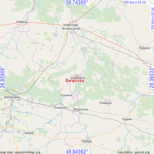
Baranivka GPS coordinates[2]
50° 17' 48.876" North, 27° 39' 43.92" East
| Map corner | latitude | longitude |
|---|---|---|
| Upper-left | 50.74395°, | 26.95908° |
| Center: | 50.29691°, | 27.6622° |
| Lower-right: | 49.84562°, | 28.36533° |
| Map W x H: | 99.9×99.9 km | = 62.1×62.1mi |
| max Lat: | 52.18903° ⇑12.1% North |
| Baranivka: | 50.29691° |
| min Lat: | ⇓87.9% South 44.39214° |
| min Long | Baranivka | max Long |
| 22.20555° | 27.6622° | 40.13222° |
| W 23.3%⇐ | ⇒76.7% E |
Elevation
Elevation of Baranivka is 223 m = 732 ft, and this is 67.2 m = 220 ft above average elevation for this country.
| Max E: |
886 m = 2907 ft | 25.6% |
| Baranivka | 223 m 732 ft | |
| Avg. | 155.8 m = 511 ft | |
Min E: |
-3 m = -10 ft | 74.4% |
See also: Ukraine elevation on elevation.city.
Geographical zone
Baranivka is located in North temperate zone (between Tropic of Cancer and the Arctic Circle). Distance of this North polar circle is 1808.7 km =1123.9 mi to North.| Distance of | km | miles | from Baranivka |
|---|---|---|---|
| North Pole | 4414.6 | 2743.1 | to North |
| Arctic Circle | 1808.7 | 1123.9 | to North |
| Tropic Cancer | 2986.6 | 1855.8 | to South |
| Equator | 5592.5 | 3475 | to South |


Nearby cities:
15 places around Baranivka: (largest is in red/bold)
• Bykivka
22.8 km =14.2 mi,  91°
91°
• Chudniv
42.3 km =26.3 mi,  130°
130°
• Denyshi
53.5 km =33.2 mi,  99°
99°
• Dovbysh
24.6 km =15.3 mi,  69°
69°
• Korets
50.2 km =31.2 mi,  315°
315°
• Liubar
42.4 km =26.3 mi,  170°
170°
• Novohrad-Volynskyi
33.2 km =20.6 mi,  354°
354°
• Novoselytsya
27.2 km =16.9 mi,  201°
201°
• Polonne
22 km =13.7 mi,  209°
209°
• Polyanka
4.7 km =2.9 mi,  156°
156°
• Poninka
15.3 km =9.5 mi,  215°
215°
• Pulyny
47.2 km =29.3 mi, 66°
• Romaniv
25.3 km =15.7 mi, 130°
• Shepetivka
44.3 km =27.5 mi,  253°
253°
• Slavuta
56.6 km =35.2 mi,  270°
270°
Sources, notices
• [Note1] Compared only with cities in Ukraine existing in our database
• [Src1] Map data: © OpenStreetMap contributors (CC-BY-SA)
• [Src2] Other city data from geonames.org with taken over terms of usage.
• [Src3] Geographical zone / Annual Mean Temperature by Robert A. Rohde @ Wikipedia
