Verbivka geodata
Verbivka (Kharkiv) is a populated place; located in Ukraine in Europe/Kiev (GMT+3) time zone. With population of 3,377 people, there are 852 cities with bigger population in this country. Compared to other cities in Ukraine, 73% of cities are located further ↓South; 84.8% of cities are located further ←West and 61% of cities have higher elevation than Verbivka. Note1


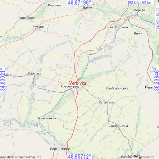
Verbivka GPS coordinates[2]
49° 25' 0.012" North, 35° 31' 59.988" East
| Map corner | latitude | longitude |
|---|---|---|
| Upper-left | 49.87196°, | 34.83021° |
| Center: | 49.41667°, | 35.53333° |
| Lower-right: | 48.95712°, | 36.23646° |
| Map W x H: | 101.7×101.7 km | = 63.2×63.2mi |
| max Lat: | 52.18903° ⇑27% North |
| Verbivka: | 49.41667° |
| min Lat: | ⇓73% South 44.39214° |
| min Long | Verbivka | max Long |
| 22.20555° | 35.53333° | 40.13222° |
| W 84.8%⇐ | ⇒15.2% E |
Elevation
Elevation of Verbivka is 102 m = 335 ft, and this is 53.8 m = 177 ft below average elevation for this country.
| Max E: |
886 m = 2907 ft | 61% |
| Avg. | 155.8 m = 511 ft | |
| Verbivka | 102 m = 335 ft | |
Min E: |
-3 m = -10 ft | 39% |
See also: Ukraine elevation on elevation.city.
Geographical zone
Verbivka is located in North temperate zone (between Tropic of Cancer and the Arctic Circle). Distance of this North polar circle is 1906.6 km =1184.7 mi to North.| Distance of | km | miles | from Verbivka |
|---|---|---|---|
| North Pole | 4512.4 | 2803.9 | to North |
| Arctic Circle | 1906.6 | 1184.7 | to North |
| Tropic Cancer | 2888.7 | 1795 | to South |
| Equator | 5494.6 | 3414.2 | to South |


Nearby cities:
15 places around Verbivka: (largest is in red/bold)
• Berezivka
12.8 km =8 mi,  78°
78°
• Chapayeve
25.3 km =15.7 mi,  102°
102°
• Chutove
42.1 km =26.2 mi,  320°
320°
• Karlivka
29.5 km =18.3 mi,  278°
278°
• Kehychivka
22 km =13.7 mi,  131°
131°
• Kolomak
49.9 km =31 mi,  340°
340°
• Krasnohrad
7.8 km =4.8 mi,  238°
238°
• Mashivka
48.3 km =30 mi,  273°
273°
• Nova Vodolaha
41.3 km =25.7 mi,  35°
35°
• Pervomays’kyy
49.4 km =30.7 mi,  93°
93°
• Sakhnovshchyna
38.4 km =23.9 mi,  140°
140°
• Tymchenky
49.1 km =30.5 mi,  115°
115°
• Valky
47 km =29.2 mi,  6°
6°
• Varvarivka
27.5 km =17.1 mi,  299°
299°
• Zachepylivka
32.7 km =20.3 mi,  220°
220°
Sources, notices
• [Note1] Compared only with cities in Ukraine existing in our database
• [Src1] Map data: © OpenStreetMap contributors (CC-BY-SA)
• [Src2] Other city data from geonames.org with taken over terms of usage.
• [Src3] Geographical zone / Annual Mean Temperature by Robert A. Rohde @ Wikipedia
