Balakliya geodata
Balakliya (Kharkiv) is a seat of a second-order administrative division; located in Ukraine in Europe/Kiev (GMT+3) time zone. With population of 31,156 people, there are 138 cities with bigger population in this country. Compared to other cities in Ukraine, 74.2% of cities are located further ↓South; 90.6% of cities are located further ←West and 68.4% of cities have higher elevation than Balakliya. Note1


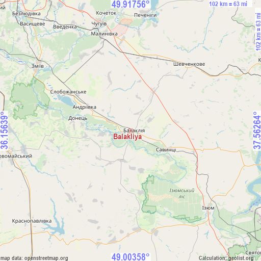
Balakliya GPS coordinates[2]
49° 27' 45.72" North, 36° 51' 34.236" East
| Map corner | latitude | longitude |
|---|---|---|
| Upper-left | 49.91756°, | 36.15639° |
| Center: | 49.4627°, | 36.85951° |
| Lower-right: | 49.00358°, | 37.56264° |
| Map W x H: | 101.6×101.6 km | = 63.1×63.1mi |
| max Lat: | 52.18903° ⇑25.8% North |
| Balakliya: | 49.4627° |
| min Lat: | ⇓74.2% South 44.39214° |
| min Long | Balakliya | max Long |
| 22.20555° | 36.85951° | 40.13222° |
| W 90.6%⇐ | ⇒9.4% E |
Elevation
Elevation of Balakliya is 79 m = 259 ft, and this is 76.8 m = 252 ft below average elevation for this country.
| Max E: |
886 m = 2907 ft | 68.4% |
| Avg. | 155.8 m = 511 ft | |
| Balakliya | 79 m = 259 ft | |
Min E: |
-3 m = -10 ft | 31.6% |
See also: Ukraine elevation on elevation.city.
Geographical zone
Balakliya is located in North temperate zone (between Tropic of Cancer and the Arctic Circle). Distance of this North polar circle is 1901.4 km =1181.5 mi to North.| Distance of | km | miles | from Balakliya |
|---|---|---|---|
| North Pole | 4507.3 | 2800.7 | to North |
| Arctic Circle | 1901.4 | 1181.5 | to North |
| Tropic Cancer | 2893.8 | 1798.1 | to South |
| Equator | 5499.7 | 3417.4 | to South |


Nearby cities:
15 places around Balakliya: (largest is in red/bold)
• Chuhuyiv
43.3 km =26.9 mi,  343°
343°
• Eskhar
41.8 km =26 mi,  332°
332°
• Izyum
39.9 km =24.8 mi,  135°
135°
• Kochetok
47.2 km =29.3 mi,  349°
349°
• Lyman
31.8 km =19.8 mi,  298°
298°
• Malynivka
40.4 km =25.1 mi, 347°
• Novopokrovka
46.9 km =29.1 mi, 331°
• Pechenihy
45.8 km =28.5 mi,  6°
6°
• Pervomays’kyy
47.4 km =29.5 mi,  259°
259°
• Petrivs’ke
31.9 km =19.8 mi,  174°
174°
• Savyntsi
16.1 km =10 mi,  114°
114°
• Shevchenkove
34.4 km =21.4 mi,  41°
41°
• Slobozhans’ke
28.3 km =17.6 mi, 301°
• Vvedenka
47.7 km =29.6 mi, 327°
• Zmiyiv
43.8 km =27.2 mi, 302°
Sources, notices
• [Note1] Compared only with cities in Ukraine existing in our database
• [Src1] Map data: © OpenStreetMap contributors (CC-BY-SA)
• [Src2] Other city data from geonames.org with taken over terms of usage.
• [Src3] Geographical zone / Annual Mean Temperature by Robert A. Rohde @ Wikipedia
