Melioratyvne geodata
Melioratyvne (Dnipropetrovsk) is a populated place; located in Ukraine in Europe/Kiev (GMT+3) time zone. With population of 4,351 people, there are 714 cities with bigger population in this country. Compared to other cities in Ukraine, 58.3% of cities are located further ↓South; 84.1% of cities are located further ←West and 71.1% of cities have higher elevation than Melioratyvne. Note1


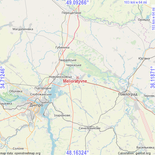
Melioratyvne GPS coordinates[2]
48° 37' 48.324" North, 35° 24' 56.088" East
| Map corner | latitude | longitude |
|---|---|---|
| Upper-left | 49.09266°, | 34.71246° |
| Center: | 48.63009°, | 35.41558° |
| Lower-right: | 48.16324°, | 36.11871° |
| Map W x H: | 103.3×103.3 km | = 64.2×64.2mi |
| max Lat: | 52.18903° ⇑41.7% North |
| Melioratyvne: | 48.63009° |
| min Lat: | ⇓58.3% South 44.39214° |
| min Long | Melioratyvne | max Long |
| 22.20555° | 35.41558° | 40.13222° |
| W 84.1%⇐ | ⇒15.9% E |
Elevation
Elevation of Melioratyvne is 72 m = 236 ft, and this is 83.8 m = 275 ft below average elevation for this country.
| Max E: |
886 m = 2907 ft | 71.1% |
| Avg. | 155.8 m = 511 ft | |
| Melioratyvne | 72 m = 236 ft | |
Min E: |
-3 m = -10 ft | 28.9% |
See also: Ukraine elevation on elevation.city.
Geographical zone
Melioratyvne is located in North temperate zone (between Tropic of Cancer and the Arctic Circle). Distance of this North polar circle is 1994 km =1239 mi to North.| Distance of | km | miles | from Melioratyvne |
|---|---|---|---|
| North Pole | 4599.9 | 2858.2 | to North |
| Arctic Circle | 1994 | 1239 | to North |
| Tropic Cancer | 2801.2 | 1740.6 | to South |
| Equator | 5407.2 | 3359.9 | to South |


Nearby cities:
15 places around Melioratyvne: (largest is in red/bold)
• Aviatorske
38.2 km =23.7 mi,  220°
220°
• Dnipro
33.6 km =20.9 mi,  235°
235°
• Hubynykha
23.2 km =14.4 mi,  329°
329°
• Kamianske
61.3 km =38.1 mi,  257°
257°
• Kaydaki
35.4 km =22 mi, 217°
• Khashchevoye
9.7 km =6 mi, 325°
• Mahdalynivka
48.9 km =30.4 mi,  311°
311°
• Novomoskovs’k
12.5 km =7.8 mi,  274°
274°
• Partyzans’ke
44.8 km =27.8 mi, 263°
• Pavlohrad
35.2 km =21.9 mi,  107°
107°
• Petrykivka
58.5 km =36.4 mi,  280°
280°
• Pidhorodne
23.5 km =14.6 mi,  254°
254°
• Spas’ke
26.9 km =16.7 mi, 278°
• Synel’nykove
35.2 km =21.9 mi,  167°
167°
• Yur”yivka
45.9 km =28.5 mi,  74°
74°
Sources, notices
• [Note1] Compared only with cities in Ukraine existing in our database
• [Src1] Map data: © OpenStreetMap contributors (CC-BY-SA)
• [Src2] Other city data from geonames.org with taken over terms of usage.
• [Src3] Geographical zone / Annual Mean Temperature by Robert A. Rohde @ Wikipedia
