Hubynykha geodata
Hubynykha (Dnipropetrovsk) is a populated place; located in Ukraine in Europe/Kiev (GMT+3) time zone. With population of 5,745 people, there are 582 cities with bigger population in this country. Compared to other cities in Ukraine, 62.2% of cities are located further ↓South; 83% of cities are located further ←West and 52.7% of cities have higher elevation than Hubynykha. Note1


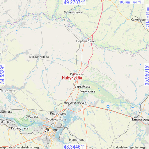
Hubynykha GPS coordinates[2]
48° 48' 35.28" North, 35° 15' 21.672" East
| Map corner | latitude | longitude |
|---|---|---|
| Upper-left | 49.27071°, | 34.5529° |
| Center: | 48.8098°, | 35.25602° |
| Lower-right: | 48.34461°, | 35.95915° |
| Map W x H: | 103×103 km | = 64×64mi |
| max Lat: | 52.18903° ⇑37.8% North |
| Hubynykha: | 48.8098° |
| min Lat: | ⇓62.2% South 44.39214° |
| min Long | Hubynykha | max Long |
| 22.20555° | 35.25602° | 40.13222° |
| W 83%⇐ | ⇒17% E |
Elevation
Elevation of Hubynykha is 126 m = 413 ft, and this is 29.8 m = 98 ft below average elevation for this country.
| Max E: |
886 m = 2907 ft | 52.7% |
| Avg. | 155.8 m = 511 ft | |
| Hubynykha | 126 m = 413 ft | |
Min E: |
-3 m = -10 ft | 47.3% |
See also: Ukraine elevation on elevation.city.
Geographical zone
Hubynykha is located in North temperate zone (between Tropic of Cancer and the Arctic Circle). Distance of this North polar circle is 1974 km =1226.6 mi to North.| Distance of | km | miles | from Hubynykha |
|---|---|---|---|
| North Pole | 4579.9 | 2845.8 | to North |
| Arctic Circle | 1974 | 1226.6 | to North |
| Tropic Cancer | 2821.2 | 1753 | to South |
| Equator | 5427.1 | 3372.2 | to South |


Nearby cities:
15 places around Hubynykha: (largest is in red/bold)
• Aviatorske
50.9 km =31.6 mi,  194°
194°
• Dnipro
42.1 km =26.2 mi,  202°
202°
• Hupalivka
50.7 km =31.5 mi,  311°
311°
• Kaydaki
49.1 km =30.5 mi, 191°
• Khashchevoye
13.5 km =8.4 mi,  152°
152°
• Mahdalynivka
27.9 km =17.3 mi,  296°
296°
• Melioratyvne
23.2 km =14.4 mi, 149°
• Novomoskovs’k
19.1 km =11.9 mi,  182°
182°
• Partyzans’ke
41.1 km =25.5 mi,  232°
232°
• Pavlohrad
54.6 km =33.9 mi,  124°
124°
• Petrykivka
46.5 km =28.9 mi,  258°
258°
• Pidhorodne
28.3 km =17.6 mi, 202°
• Spas’ke
21.7 km =13.5 mi,  222°
222°
• Yur”yivka
56.5 km =35.1 mi,  98°
98°
• Zachepylivka
42.7 km =26.5 mi,  358°
358°
Sources, notices
• [Note1] Compared only with cities in Ukraine existing in our database
• [Src1] Map data: © OpenStreetMap contributors (CC-BY-SA)
• [Src2] Other city data from geonames.org with taken over terms of usage.
• [Src3] Geographical zone / Annual Mean Temperature by Robert A. Rohde @ Wikipedia
