Synel’nykove geodata
Synel’nykove (Dnipropetrovsk) is a seat of a second-order administrative division; located in Ukraine in Europe/Kiev (GMT+3) time zone. With population of 31,900 people, there are 136 cities with bigger population in this country. Compared to other cities in Ukraine, 50.4% of cities are located further ↓South; 84.6% of cities are located further ←West and 60.8% of cities have lower elevation than Synel’nykove. Note1


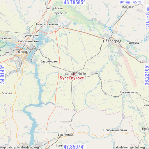
Synel’nykove GPS coordinates[2]
48° 19' 13.584" North, 35° 31' 4.512" East
| Map corner | latitude | longitude |
|---|---|---|
| Upper-left | 48.78585°, | 34.8148° |
| Center: | 48.32044°, | 35.51792° |
| Lower-right: | 47.85074°, | 36.22105° |
| Map W x H: | 104×104 km | = 64.6×64.6mi |
| max Lat: | 52.18903° ⇑49.6% North |
| Synel’nykove: | 48.32044° |
| min Lat: | ⇓50.4% South 44.39214° |
| min Long | Synel’nykove | max Long |
| 22.20555° | 35.51792° | 40.13222° |
| W 84.6%⇐ | ⇒15.4% E |
Elevation
Elevation of Synel’nykove is 171 m = 561 ft, and this is 15.2 m = 50 ft above average elevation for this country.
| Max E: |
886 m = 2907 ft | 39.2% |
| Synel’nykove | 171 m 561 ft | |
| Avg. | 155.8 m = 511 ft | |
Min E: |
-3 m = -10 ft | 60.8% |
See also: Ukraine elevation on elevation.city.
Geographical zone
Synel’nykove is located in North temperate zone (between Tropic of Cancer and the Arctic Circle). Distance of this North polar circle is 2028.4 km =1260.4 mi to North.| Distance of | km | miles | from Synel’nykove |
|---|---|---|---|
| North Pole | 4634.3 | 2879.6 | to North |
| Arctic Circle | 2028.4 | 1260.4 | to North |
| Tropic Cancer | 2766.8 | 1719.2 | to South |
| Equator | 5372.7 | 3338.4 | to South |


Nearby cities:
15 places around Synel’nykove: (largest is in red/bold)
• Aviatorske
32.7 km =20.3 mi,  279°
279°
• Dnipro
38.6 km =24 mi,  293°
293°
• Hubynykha
57.7 km =35.9 mi,  340°
340°
• Kaydaki
29.8 km =18.5 mi, 282°
• Khashchevoye
44.3 km =27.5 mi, 342°
• Melioratyvne
35.2 km =21.9 mi,  347°
347°
• Novomoskovs’k
40.6 km =25.2 mi,  330°
330°
• Novomykolayivka
47.9 km =29.8 mi,  142°
142°
• Pavlohrad
35.3 km =21.9 mi,  47°
47°
• Pidhorodne
41.5 km =25.8 mi,  313°
313°
• Solone
49.4 km =30.7 mi,  255°
255°
• Spas’ke
51.5 km =32 mi,  318°
318°
• Surs’ko-Mykhaylivka
58.7 km =36.5 mi, 264°
• Vasyl’kivka
39.5 km =24.5 mi,  108°
108°
• Vil’nyans’k
42.3 km =26.3 mi,  188°
188°
Sources, notices
• [Note1] Compared only with cities in Ukraine existing in our database
• [Src1] Map data: © OpenStreetMap contributors (CC-BY-SA)
• [Src2] Other city data from geonames.org with taken over terms of usage.
• [Src3] Geographical zone / Annual Mean Temperature by Robert A. Rohde @ Wikipedia
