Lypnyazhka geodata
Lypnyazhka (Kirovohrad) is a populated place; located in Ukraine in Europe/Kiev (GMT+3) time zone. With population of 4,272 people, there are 726 cities with bigger population in this country. Compared to other cities in Ukraine, 54.1% of cities are located further ↓South; 60.9% of cities are located further →East and 50.8% of cities have higher elevation than Lypnyazhka. Note1


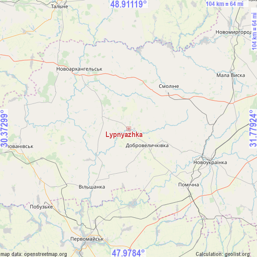
Lypnyazhka GPS coordinates[2]
48° 26' 48.984" North, 31° 4' 33.996" East
| Map corner | latitude | longitude |
|---|---|---|
| Upper-left | 48.91119°, | 30.37299° |
| Center: | 48.44694°, | 31.07611° |
| Lower-right: | 47.9784°, | 31.77924° |
| Map W x H: | 103.7×103.7 km | = 64.4×64.4mi |
| max Lat: | 52.18903° ⇑45.9% North |
| Lypnyazhka: | 48.44694° |
| min Lat: | ⇓54.1% South 44.39214° |
| min Long | Lypnyazhka | max Long |
| 22.20555° | 31.07611° | 40.13222° |
| W 39.1%⇐ | ⇒60.9% E |
Elevation
Elevation of Lypnyazhka is 131 m = 430 ft, and this is 24.8 m = 81 ft below average elevation for this country.
| Max E: |
886 m = 2907 ft | 50.8% |
| Avg. | 155.8 m = 511 ft | |
| Lypnyazhka | 131 m = 430 ft | |
Min E: |
-3 m = -10 ft | 49.2% |
See also: Ukraine elevation on elevation.city.
Geographical zone
Lypnyazhka is located in North temperate zone (between Tropic of Cancer and the Arctic Circle). Distance of this North polar circle is 2014.4 km =1251.7 mi to North.| Distance of | km | miles | from Lypnyazhka |
|---|---|---|---|
| North Pole | 4620.3 | 2870.9 | to North |
| Arctic Circle | 2014.4 | 1251.7 | to North |
| Tropic Cancer | 2780.9 | 1728 | to South |
| Equator | 5386.8 | 3347.2 | to South |


Nearby cities:
15 places around Lypnyazhka: (largest is in red/bold)
• Dobrovelychkivka
10.1 km =6.3 mi,  130°
130°
• Holovanivs’k
45.9 km =28.5 mi,  261°
261°
• Lysa Hora
30.8 km =19.1 mi,  175°
175°
• Mala Vyska
46.7 km =29 mi,  62°
62°
• Myhiya
46.5 km =28.9 mi,  191°
191°
• Novoarkhanhel’s’k
30.2 km =18.8 mi,  321°
321°
• Novoukrayinka
36 km =22.4 mi,  111°
111°
• Perehonivka
42.2 km =26.2 mi,  283°
283°
• Pervomays’k
47.8 km =29.7 mi,  200°
200°
• Pidhorodna
40.2 km =25 mi, 200°
• Pobugskoye
47.5 km =29.5 mi,  228°
228°
• Pomichna
33.9 km =21.1 mi, 132°
• Tyshkivka
11.3 km =7 mi,  299°
299°
• Vil’shanka
27.7 km =17.2 mi,  212°
212°
• Zlynka
34.4 km =21.4 mi,  82°
82°
Sources, notices
• [Note1] Compared only with cities in Ukraine existing in our database
• [Src1] Map data: © OpenStreetMap contributors (CC-BY-SA)
• [Src2] Other city data from geonames.org with taken over terms of usage.
• [Src3] Geographical zone / Annual Mean Temperature by Robert A. Rohde @ Wikipedia
