Lymanske geodata
Lymanske (Odesa) is a populated place; located in Ukraine in Europe/Kiev (GMT+3) time zone. With population of 8,600 people, there are 411 cities with bigger population in this country. Compared to other cities in Ukraine, 66.1% of cities are located further ↑North; 68% of cities are located further →East and 95.3% of cities have higher elevation than Lymanske. Note1


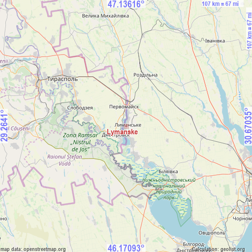
Lymanske GPS coordinates[2]
46° 39' 20.52" North, 29° 58' 1.992" East
| Map corner | latitude | longitude |
|---|---|---|
| Upper-left | 47.13616°, | 29.2641° |
| Center: | 46.6557°, | 29.96722° |
| Lower-right: | 46.17093°, | 30.67035° |
| Map W x H: | 107.3×107.3 km | = 66.7×66.7mi |
| max Lat: | 52.18903° ⇑66.1% North |
| Lymanske: | 46.6557° |
| min Lat: | ⇓33.9% South 44.39214° |
| min Long | Lymanske | max Long |
| 22.20555° | 29.96722° | 40.13222° |
| W 32%⇐ | ⇒68% E |
Elevation
Elevation of Lymanske is 11 m = 36 ft, and this is 144.8 m = 475 ft below average elevation for this country.
| Max E: |
886 m = 2907 ft | 95.3% |
| Avg. | 155.8 m = 511 ft | |
| Lymanske | 11 m = 36 ft | |
Min E: |
-3 m = -10 ft | 4.7% |
See also: Ukraine elevation on elevation.city.
Geographical zone
Lymanske is located in North temperate zone (between Tropic of Cancer and the Arctic Circle). Distance of this North polar circle is 2213.5 km =1375.4 mi to North.| Distance of | km | miles | from Lymanske |
|---|---|---|---|
| North Pole | 4819.4 | 2994.6 | to North |
| Arctic Circle | 2213.5 | 1375.4 | to North |
| Tropic Cancer | 2581.7 | 1604.2 | to South |
| Equator | 5187.6 | 3223.4 | to South |


Nearby cities:
15 places around Lymanske: (largest is in red/bold)
• Bilyayivka
27.1 km =16.8 mi,  135°
135°
• Ivanivka
52.2 km =32.4 mi,  47°
47°
• Kamyshevka Vtoraya
48.1 km =29.9 mi,  192°
192°
• Kuchurhan
58 km =36 mi,  346°
346°
• Mayaky
35.4 km =22 mi, 138°
• Ovidiopol
57.9 km =36 mi, 141°
• Pavlivka
11.7 km =7.3 mi,  7°
7°
• Rozdil’na
22.5 km =14 mi,  22°
22°
• Starokozache
35.4 km =22 mi,  177°
177°
• Stepanivka
15.5 km =9.6 mi, 5°
• Stepove
10.1 km =6.3 mi,  57°
57°
• Teplodar
32 km =19.9 mi,  121°
121°
• Usatove
54.6 km =33.9 mi,  104°
104°
• Velyka Mykhaylivka
47.9 km =29.8 mi, 349°
• Velykoploske
45.6 km =28.3 mi,  330°
330°
Sources, notices
• [Note1] Compared only with cities in Ukraine existing in our database
• [Src1] Map data: © OpenStreetMap contributors (CC-BY-SA)
• [Src2] Other city data from geonames.org with taken over terms of usage.
• [Src3] Geographical zone / Annual Mean Temperature by Robert A. Rohde @ Wikipedia
