Stepove geodata
Stepove (Odesa) is a populated place; located in Ukraine in Europe/Kiev (GMT+3) time zone. With population of 1,549 people, there are 1199 cities with bigger population in this country. Compared to other cities in Ukraine, 65.8% of cities are located further ↑North; 67.4% of cities are located further →East and 77.2% of cities have higher elevation than Stepove. Note1


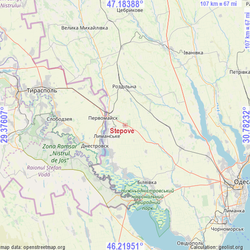
Stepove GPS coordinates[2]
46° 42' 13.86" North, 30° 4' 45.084" East
| Map corner | latitude | longitude |
|---|---|---|
| Upper-left | 47.18388°, | 29.37607° |
| Center: | 46.70385°, | 30.07919° |
| Lower-right: | 46.21951°, | 30.78232° |
| Map W x H: | 107.2×107.2 km | = 66.6×66.6mi |
| max Lat: | 52.18903° ⇑65.8% North |
| Stepove: | 46.70385° |
| min Lat: | ⇓34.2% South 44.39214° |
| min Long | Stepove | max Long |
| 22.20555° | 30.07919° | 40.13222° |
| W 32.6%⇐ | ⇒67.4% E |
Elevation
Elevation of Stepove is 53 m = 174 ft, and this is 102.8 m = 337 ft below average elevation for this country.
| Max E: |
886 m = 2907 ft | 77.2% |
| Avg. | 155.8 m = 511 ft | |
| Stepove | 53 m = 174 ft | |
Min E: |
-3 m = -10 ft | 22.8% |
See also: Ukraine elevation on elevation.city.
Geographical zone
Stepove is located in North temperate zone (between Tropic of Cancer and the Arctic Circle). Distance of this North polar circle is 2208.2 km =1372.1 mi to North.| Distance of | km | miles | from Stepove |
|---|---|---|---|
| North Pole | 4814.1 | 2991.3 | to North |
| Arctic Circle | 2208.2 | 1372.1 | to North |
| Tropic Cancer | 2587.1 | 1607.5 | to South |
| Equator | 5193 | 3226.8 | to South |


Nearby cities:
15 places around Stepove: (largest is in red/bold)
• Bilyayivka
26.7 km =16.6 mi,  156°
156°
• Ivanivka
42.4 km =26.3 mi,  44°
44°
• Kamyshevka Vtoraya
55.6 km =34.5 mi,  199°
199°
• Krasnosilka
53.8 km =33.4 mi,  99°
99°
• Kremidivka
53.9 km =33.5 mi,  86°
86°
• Lymanske
10.1 km =6.3 mi,  237°
237°
• Mayaky
35.2 km =21.9 mi,  154°
154°
• Pavlivka
9.4 km =5.8 mi,  311°
311°
• Rozdil’na
15.5 km =9.6 mi,  0°
0°
• Starokozache
41.4 km =25.7 mi,  189°
189°
• Stepanivka
12.3 km =7.6 mi,  325°
325°
• Teplodar
28.9 km =18 mi,  139°
139°
• Usatove
48.2 km =30 mi,  113°
113°
• Velyka Mykhaylivka
45.1 km =28 mi,  338°
338°
• Velykoploske
46.2 km =28.7 mi,  317°
317°
Sources, notices
• [Note1] Compared only with cities in Ukraine existing in our database
• [Src1] Map data: © OpenStreetMap contributors (CC-BY-SA)
• [Src2] Other city data from geonames.org with taken over terms of usage.
• [Src3] Geographical zone / Annual Mean Temperature by Robert A. Rohde @ Wikipedia
