Stavyshche geodata
Stavyshche (Zhytomyr) is a populated place; located in Ukraine in Europe/Kiev (GMT+3) time zone. With population of 7,634 people, there are 471 cities with bigger population in this country. Compared to other cities in Ukraine, 89.8% of cities are located further ↓South; 70.2% of cities are located further →East and 63.5% of cities have lower elevation than Stavyshche. Note1


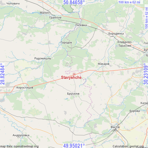
Stavyshche GPS coordinates[2]
50° 24' 1.836" North, 29° 31' 40.656" East
| Map corner | latitude | longitude |
|---|---|---|
| Upper-left | 50.84658°, | 28.82484° |
| Center: | 50.40051°, | 29.52796° |
| Lower-right: | 49.95021°, | 30.23109° |
| Map W x H: | 99.7×99.7 km | = 62×62mi |
| max Lat: | 52.18903° ⇑10.2% North |
| Stavyshche: | 50.40051° |
| min Lat: | ⇓89.8% South 44.39214° |
| min Long | Stavyshche | max Long |
| 22.20555° | 29.52796° | 40.13222° |
| W 29.8%⇐ | ⇒70.2% E |
Elevation
Elevation of Stavyshche is 181 m = 594 ft, and this is 25.2 m = 83 ft above average elevation for this country.
| Max E: |
886 m = 2907 ft | 36.5% |
| Stavyshche | 181 m 594 ft | |
| Avg. | 155.8 m = 511 ft | |
Min E: |
-3 m = -10 ft | 63.5% |
See also: Ukraine elevation on elevation.city.
Geographical zone
Stavyshche is located in North temperate zone (between Tropic of Cancer and the Arctic Circle). Distance of this North polar circle is 1797.2 km =1116.7 mi to North.| Distance of | km | miles | from Stavyshche |
|---|---|---|---|
| North Pole | 4403.1 | 2736 | to North |
| Arctic Circle | 1797.2 | 1116.7 | to North |
| Tropic Cancer | 2998.1 | 1862.9 | to South |
| Equator | 5604 | 3482.2 | to South |


Nearby cities:
15 places around Stavyshche: (largest is in red/bold)
• Bila Krynytsya
26.9 km =16.7 mi,  351°
351°
• Borodianka
38.8 km =24.1 mi,  45°
45°
• Brusyliv
12.9 km =8 mi,  180°
180°
• Fastiv
45.4 km =28.2 mi,  142°
142°
• Horodok
22.1 km =13.7 mi, 347°
• Klavdiyevo-Tarasove
39.8 km =24.7 mi,  59°
59°
• Kodra
21.7 km =13.5 mi,  5°
5°
• Kornyn
33.9 km =21.1 mi, 179°
• Korostyshiv
34.7 km =21.6 mi,  254°
254°
• Kvitneve
45.9 km =28.5 mi, 179°
• Makariv
21.3 km =13.2 mi,  70°
70°
• Malyn
46.1 km =28.6 mi,  333°
333°
• Piskivka
33.2 km =20.6 mi, 11°
• Radomyshl
23.7 km =14.7 mi,  296°
296°
• Yasnohorodka
35.4 km =22 mi,  98°
98°
Sources, notices
• [Note1] Compared only with cities in Ukraine existing in our database
• [Src1] Map data: © OpenStreetMap contributors (CC-BY-SA)
• [Src2] Other city data from geonames.org with taken over terms of usage.
• [Src3] Geographical zone / Annual Mean Temperature by Robert A. Rohde @ Wikipedia
