Polohy geodata
Polohy (Zaporizhia) is a seat of a second-order administrative division; located in Ukraine in Europe/Zaporozhye (GMT+3) time zone. With population of 21,380 people, there are 191 cities with bigger population in this country. Compared to other cities in Ukraine, 60.8% of cities are located further ↑North; 88.5% of cities are located further ←West and 62.7% of cities have higher elevation than Polohy. Note1


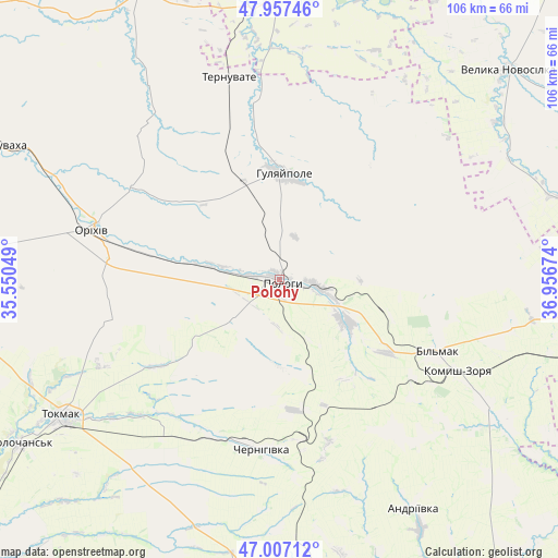
Polohy GPS coordinates[2]
47° 29' 3.984" North, 36° 15' 12.996" East
| Map corner | latitude | longitude |
|---|---|---|
| Upper-left | 47.95746°, | 35.55049° |
| Center: | 47.48444°, | 36.25361° |
| Lower-right: | 47.00712°, | 36.95674° |
| Map W x H: | 105.7×105.7 km | = 65.7×65.7mi |
| max Lat: | 52.18903° ⇑60.8% North |
| Polohy: | 47.48444° |
| min Lat: | ⇓39.2% South 44.39214° |
| min Long | Polohy | max Long |
| 22.20555° | 36.25361° | 40.13222° |
| W 88.5%⇐ | ⇒11.5% E |
Elevation
Elevation of Polohy is 98 m = 322 ft, and this is 57.8 m = 190 ft below average elevation for this country.
| Max E: |
886 m = 2907 ft | 62.7% |
| Avg. | 155.8 m = 511 ft | |
| Polohy | 98 m = 322 ft | |
Min E: |
-3 m = -10 ft | 37.3% |
See also: Ukraine elevation on elevation.city.
Geographical zone
Polohy is located in North temperate zone (between Tropic of Cancer and the Arctic Circle). Distance of this North polar circle is 2121.4 km =1318.2 mi to North.| Distance of | km | miles | from Polohy |
|---|---|---|---|
| North Pole | 4727.3 | 2937.4 | to North |
| Arctic Circle | 2121.4 | 1318.2 | to North |
| Tropic Cancer | 2673.9 | 1661.5 | to South |
| Equator | 5279.8 | 3280.7 | to South |


Nearby cities:
15 places around Polohy: (largest is in red/bold)
• Chapayevka
7 km =4.3 mi,  102°
102°
• Chernihivka
32.4 km =20.1 mi,  192°
192°
• Hulyaypole
20 km =12.4 mi,  0°
0°
• Kirove
45.9 km =28.5 mi,  294°
294°
• Komysh-Zorya
37.4 km =23.2 mi,  117°
117°
• Kuybysheve
32.9 km =20.4 mi, 115°
• Mala Tokmachka
27.7 km =17.2 mi,  281°
281°
• Orikhiv
36.3 km =22.6 mi, 284°
• Pokrovs’ke
55 km =34.2 mi,  357°
357°
• Preobrazhenka
34.2 km =21.3 mi, 286°
• Temriuk
59.8 km =37.2 mi,  113°
113°
• Ternuvate
39.6 km =24.6 mi,  346°
346°
• Tokmak
48.1 km =29.9 mi,  237°
237°
• Velyka Novosilka
59.2 km =36.8 mi,  47°
47°
• Zaliznychne
19.8 km =12.3 mi,  340°
340°
Sources, notices
• [Note1] Compared only with cities in Ukraine existing in our database
• [Src1] Map data: © OpenStreetMap contributors (CC-BY-SA)
• [Src2] Other city data from geonames.org with taken over terms of usage.
• [Src3] Geographical zone / Annual Mean Temperature by Robert A. Rohde @ Wikipedia
