Hulyaypole geodata
Hulyaypole (Zaporizhia) is a seat of a second-order administrative division; located in Ukraine in Europe/Zaporozhye (GMT+3) time zone. With population of 16,442 people, there are 235 cities with bigger population in this country. Compared to other cities in Ukraine, 59.5% of cities are located further ↑North; 88.6% of cities are located further ←West and 58.1% of cities have higher elevation than Hulyaypole. Note1


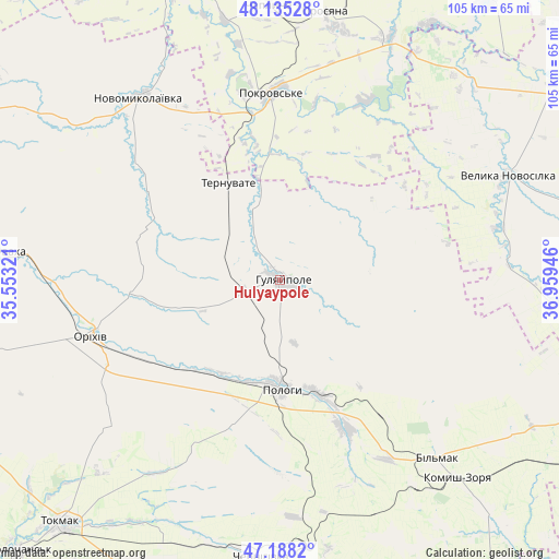
Hulyaypole GPS coordinates[2]
47° 39' 50.004" North, 36° 15' 22.788" East
| Map corner | latitude | longitude |
|---|---|---|
| Upper-left | 48.13528°, | 35.55321° |
| Center: | 47.66389°, | 36.25633° |
| Lower-right: | 47.1882°, | 36.95946° |
| Map W x H: | 105.3×105.3 km | = 65.4×65.4mi |
| max Lat: | 52.18903° ⇑59.5% North |
| Hulyaypole: | 47.66389° |
| min Lat: | ⇓40.5% South 44.39214° |
| min Long | Hulyaypole | max Long |
| 22.20555° | 36.25633° | 40.13222° |
| W 88.6%⇐ | ⇒11.4% E |
Elevation
Elevation of Hulyaypole is 112 m = 367 ft, and this is 43.8 m = 144 ft below average elevation for this country.
| Max E: |
886 m = 2907 ft | 58.1% |
| Avg. | 155.8 m = 511 ft | |
| Hulyaypole | 112 m = 367 ft | |
Min E: |
-3 m = -10 ft | 41.9% |
See also: Ukraine elevation on elevation.city.
Geographical zone
Hulyaypole is located in North temperate zone (between Tropic of Cancer and the Arctic Circle). Distance of this North polar circle is 2101.4 km =1305.7 mi to North.| Distance of | km | miles | from Hulyaypole |
|---|---|---|---|
| North Pole | 4707.3 | 2925 | to North |
| Arctic Circle | 2101.4 | 1305.7 | to North |
| Tropic Cancer | 2693.8 | 1673.8 | to South |
| Equator | 5299.7 | 3293.1 | to South |


Nearby cities:
15 places around Hulyaypole: (largest is in red/bold)
• Chapayevka
22.4 km =13.9 mi,  162°
162°
• Chernihivka
52.1 km =32.4 mi,  187°
187°
• Kirove
42 km =26.1 mi,  268°
268°
• Komysh-Zorya
49.7 km =30.9 mi,  138°
138°
• Komyshuvakha
54.7 km =34 mi,  276°
276°
• Kuybysheve
45 km =28 mi, 139°
• Mala Tokmachka
30.8 km =19.1 mi,  242°
242°
• Novomykolayivka
43.5 km =27 mi,  323°
323°
• Orikhiv
36.9 km =22.9 mi,  253°
253°
• Pokrovs’ke
35.1 km =21.8 mi,  356°
356°
• Polohy
20 km =12.4 mi,  180°
180°
• Preobrazhenka
34.5 km =21.4 mi, 252°
• Ternuvate
20.9 km =13 mi,  332°
332°
• Velyka Novosilka
47.8 km =29.7 mi,  65°
65°
• Zaliznychne
6.9 km =4.3 mi,  259°
259°
Sources, notices
• [Note1] Compared only with cities in Ukraine existing in our database
• [Src1] Map data: © OpenStreetMap contributors (CC-BY-SA)
• [Src2] Other city data from geonames.org with taken over terms of usage.
• [Src3] Geographical zone / Annual Mean Temperature by Robert A. Rohde @ Wikipedia
