Kholmy geodata
Kholmy (Chernihiv) is a populated place; located in Ukraine in Europe/Kiev (GMT+3) time zone. With population of 3,146 people, there are 900 cities with bigger population in this country. Compared to other cities in Ukraine, 99.5% of cities are located further ↓South; 54.7% of cities are located further →East and 56.3% of cities have lower elevation than Kholmy. Note1


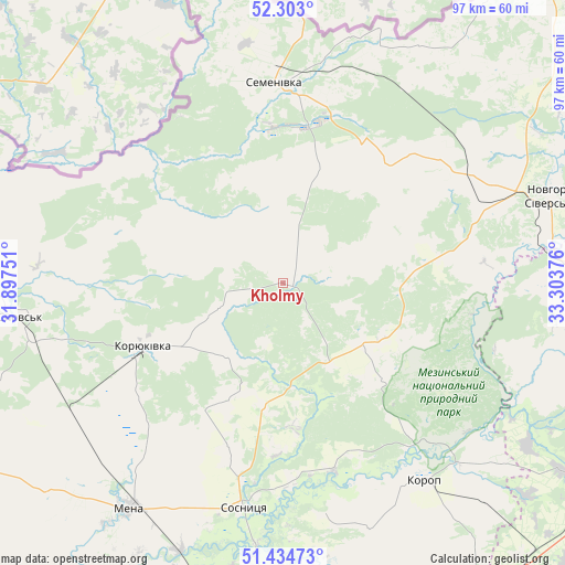
Kholmy GPS coordinates[2]
51° 52' 15.456" North, 32° 36' 2.268" East
| Map corner | latitude | longitude |
|---|---|---|
| Upper-left | 52.303°, | 31.89751° |
| Center: | 51.87096°, | 32.60063° |
| Lower-right: | 51.43473°, | 33.30376° |
| Map W x H: | 96.5×96.5 km | = 60×60mi |
| max Lat: | 52.18903° ⇑0.5% North |
| Kholmy: | 51.87096° |
| min Lat: | ⇓99.5% South 44.39214° |
| min Long | Kholmy | max Long |
| 22.20555° | 32.60063° | 40.13222° |
| W 45.3%⇐ | ⇒54.7% E |
Elevation
Elevation of Kholmy is 156 m = 512 ft, and this is 0.19999999999999 m = 1 ft above average elevation for this country.
| Max E: |
886 m = 2907 ft | 43.7% |
| Kholmy | 156 m 512 ft | |
| Avg. | 155.8 m = 511 ft | |
Min E: |
-3 m = -10 ft | 56.3% |
See also: Ukraine elevation on elevation.city.
Geographical zone
Kholmy is located in North temperate zone (between Tropic of Cancer and the Arctic Circle). Distance of this North polar circle is 1633.7 km =1015.1 mi to North.| Distance of | km | miles | from Kholmy |
|---|---|---|---|
| North Pole | 4239.6 | 2634.4 | to North |
| Arctic Circle | 1633.7 | 1015.1 | to North |
| Tropic Cancer | 3161.6 | 1964.5 | to South |
| Equator | 5767.5 | 3583.8 | to South |


Nearby cities:
15 places around Kholmy: (largest is in red/bold)
• Avdiyivka
17.3 km =10.7 mi,  127°
127°
• Bakhmach
75.5 km =46.9 mi,  170°
170°
• Baturyn
61.5 km =38.2 mi,  161°
161°
• Berezna
65.3 km =40.6 mi,  239°
239°
• Borzna
69.6 km =43.2 mi,  189°
189°
• Horodnya
68.9 km =42.8 mi,  271°
271°
• Korop
41.9 km =26 mi,  143°
143°
• Koryukivka
26.8 km =16.7 mi, 244°
• Krolevets’
64.9 km =40.3 mi,  123°
123°
• Mena
47 km =29.2 mi,  214°
214°
• Novhorod-Sivers’kyy
47.7 km =29.6 mi,  71°
71°
• Semenivka
34.2 km =21.3 mi,  357°
357°
• Shchors
45.4 km =28.2 mi,  262°
262°
• Shostka
59.7 km =37.1 mi,  90°
90°
• Sosnytsya
39.2 km =24.4 mi, 190°
Sources, notices
• [Note1] Compared only with cities in Ukraine existing in our database
• [Src1] Map data: © OpenStreetMap contributors (CC-BY-SA)
• [Src2] Other city data from geonames.org with taken over terms of usage.
• [Src3] Geographical zone / Annual Mean Temperature by Robert A. Rohde @ Wikipedia
