Sosnytsya geodata
Sosnytsya (Chernihiv) is a seat of a second-order administrative division; located in Ukraine in Europe/Kiev (GMT+3) time zone. With population of 7,825 people, there are 457 cities with bigger population in this country. Compared to other cities in Ukraine, 98.2% of cities are located further ↓South; 55.5% of cities are located further →East and 56.1% of cities have higher elevation than Sosnytsya. Note1


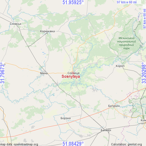
Sosnytsya GPS coordinates[2]
51° 31' 25.932" North, 32° 29' 59.46" East
| Map corner | latitude | longitude |
|---|---|---|
| Upper-left | 51.95925°, | 31.79673° |
| Center: | 51.52387°, | 32.49985° |
| Lower-right: | 51.08429°, | 33.20298° |
| Map W x H: | 97.3×97.3 km | = 60.5×60.5mi |
| max Lat: | 52.18903° ⇑1.8% North |
| Sosnytsya: | 51.52387° |
| min Lat: | ⇓98.2% South 44.39214° |
| min Long | Sosnytsya | max Long |
| 22.20555° | 32.49985° | 40.13222° |
| W 44.5%⇐ | ⇒55.5% E |
Elevation
Elevation of Sosnytsya is 117 m = 384 ft, and this is 38.8 m = 127 ft below average elevation for this country.
| Max E: |
886 m = 2907 ft | 56.1% |
| Avg. | 155.8 m = 511 ft | |
| Sosnytsya | 117 m = 384 ft | |
Min E: |
-3 m = -10 ft | 43.9% |
See also: Ukraine elevation on elevation.city.
Geographical zone
Sosnytsya is located in North temperate zone (between Tropic of Cancer and the Arctic Circle). Distance of this North polar circle is 1672.3 km =1039.1 mi to North.| Distance of | km | miles | from Sosnytsya |
|---|---|---|---|
| North Pole | 4278.1 | 2658.3 | to North |
| Arctic Circle | 1672.3 | 1039.1 | to North |
| Tropic Cancer | 3123 | 1940.5 | to South |
| Equator | 5728.9 | 3559.8 | to South |


Nearby cities:
15 places around Sosnytsya: (largest is in red/bold)
• Avdiyivka
34.9 km =21.7 mi,  36°
36°
• Bakhmach
40.7 km =25.3 mi,  152°
152°
• Bakhmach
44.6 km =27.7 mi, 148°
• Baturyn
32.9 km =20.4 mi,  127°
127°
• Berezna
49.7 km =30.9 mi,  276°
276°
• Borzna
30.4 km =18.9 mi,  189°
189°
• Kholmy
39.2 km =24.4 mi,  10°
10°
• Konotop
58.1 km =36.1 mi,  122°
122°
• Korop
32.1 km =19.9 mi,  81°
81°
• Koryukivka
32.3 km =20.1 mi,  327°
327°
• Krolevets’
61.3 km =38.1 mi,  87°
87°
• Kruty
58.4 km =36.3 mi,  207°
207°
• Kulykivka
61.4 km =38.2 mi,  254°
254°
• Mena
19.7 km =12.2 mi,  269°
269°
• Shchors
50.4 km =31.3 mi,  310°
310°
Sources, notices
• [Note1] Compared only with cities in Ukraine existing in our database
• [Src1] Map data: © OpenStreetMap contributors (CC-BY-SA)
• [Src2] Other city data from geonames.org with taken over terms of usage.
• [Src3] Geographical zone / Annual Mean Temperature by Robert A. Rohde @ Wikipedia
