Borzna geodata
Borzna (Chernihiv) is a seat of a second-order administrative division; located in Ukraine in Europe/Kiev (GMT+3) time zone. With population of 11,363 people, there are 322 cities with bigger population in this country. Compared to other cities in Ukraine, 97.1% of cities are located further ↓South; 55.7% of cities are located further →East and 51.1% of cities have higher elevation than Borzna. Note1


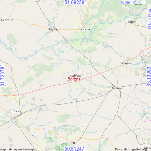
Borzna GPS coordinates[2]
51° 15' 16.704" North, 32° 25' 36.84" East
| Map corner | latitude | longitude |
|---|---|---|
| Upper-left | 51.69259°, | 31.72378° |
| Center: | 51.25464°, | 32.4269° |
| Lower-right: | 50.81247°, | 33.13003° |
| Map W x H: | 97.9×97.9 km | = 60.8×60.8mi |
| max Lat: | 52.18903° ⇑2.9% North |
| Borzna: | 51.25464° |
| min Lat: | ⇓97.1% South 44.39214° |
| min Long | Borzna | max Long |
| 22.20555° | 32.4269° | 40.13222° |
| W 44.3%⇐ | ⇒55.7% E |
Elevation
Elevation of Borzna is 130 m = 427 ft, and this is 25.8 m = 85 ft below average elevation for this country.
| Max E: |
886 m = 2907 ft | 51.1% |
| Avg. | 155.8 m = 511 ft | |
| Borzna | 130 m = 427 ft | |
Min E: |
-3 m = -10 ft | 48.9% |
See also: Ukraine elevation on elevation.city.
Geographical zone
Borzna is located in North temperate zone (between Tropic of Cancer and the Arctic Circle). Distance of this North polar circle is 1702.2 km =1057.7 mi to North.| Distance of | km | miles | from Borzna |
|---|---|---|---|
| North Pole | 4308.1 | 2676.9 | to North |
| Arctic Circle | 1702.2 | 1057.7 | to North |
| Tropic Cancer | 3093.1 | 1922 | to South |
| Equator | 5699 | 3541.2 | to South |


Nearby cities:
15 places around Borzna: (largest is in red/bold)
• Bakhmach
24.9 km =15.5 mi,  103°
103°
• Bakhmach
29.5 km =18.3 mi,  105°
105°
• Baturyn
32.9 km =20.4 mi,  72°
72°
• Berezna
56.8 km =35.3 mi,  308°
308°
• Druzhba
50.6 km =31.4 mi,  185°
185°
• Ichnya
43.7 km =27.2 mi,  182°
182°
• Konotop
54 km =33.6 mi,  91°
91°
• Korop
50.6 km =31.4 mi,  46°
46°
• Kruty
31.1 km =19.3 mi,  225°
225°
• Kulykivka
55.8 km =34.7 mi,  283°
283°
• Kunashëvka
37.3 km =23.2 mi, 230°
• Mena
33.1 km =20.6 mi,  333°
333°
• Nizhyn
44.1 km =27.4 mi,  238°
238°
• Sosnytsya
30.4 km =18.9 mi,  9°
9°
• Talalayivka
48.3 km =30 mi, 226°
Sources, notices
• [Note1] Compared only with cities in Ukraine existing in our database
• [Src1] Map data: © OpenStreetMap contributors (CC-BY-SA)
• [Src2] Other city data from geonames.org with taken over terms of usage.
• [Src3] Geographical zone / Annual Mean Temperature by Robert A. Rohde @ Wikipedia
