Koryukivka geodata
Koryukivka (Chernihiv) is a seat of a second-order administrative division; located in Ukraine in Europe/Kiev (GMT+3) time zone. With population of 14,215 people, there are 268 cities with bigger population in this country. Compared to other cities in Ukraine, 99.1% of cities are located further ↓South; 56.4% of cities are located further →East and 51.1% of cities have higher elevation than Koryukivka. Note1


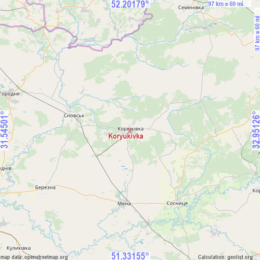
Koryukivka GPS coordinates[2]
51° 46' 7.572" North, 32° 14' 53.268" East
| Map corner | latitude | longitude |
|---|---|---|
| Upper-left | 52.20179°, | 31.54501° |
| Center: | 51.76877°, | 32.24813° |
| Lower-right: | 51.33155°, | 32.95126° |
| Map W x H: | 96.8×96.8 km | = 60.1×60.1mi |
| max Lat: | 52.18903° ⇑0.9% North |
| Koryukivka: | 51.76877° |
| min Lat: | ⇓99.1% South 44.39214° |
| min Long | Koryukivka | max Long |
| 22.20555° | 32.24813° | 40.13222° |
| W 43.6%⇐ | ⇒56.4% E |
Elevation
Elevation of Koryukivka is 130 m = 427 ft, and this is 25.8 m = 85 ft below average elevation for this country.
| Max E: |
886 m = 2907 ft | 51.1% |
| Avg. | 155.8 m = 511 ft | |
| Koryukivka | 130 m = 427 ft | |
Min E: |
-3 m = -10 ft | 48.9% |
See also: Ukraine elevation on elevation.city.
Geographical zone
Koryukivka is located in North temperate zone (between Tropic of Cancer and the Arctic Circle). Distance of this North polar circle is 1645 km =1022.2 mi to North.| Distance of | km | miles | from Koryukivka |
|---|---|---|---|
| North Pole | 4250.9 | 2641.4 | to North |
| Arctic Circle | 1645 | 1022.2 | to North |
| Tropic Cancer | 3150.2 | 1957.4 | to South |
| Equator | 5756.1 | 3576.7 | to South |


Nearby cities:
15 places around Koryukivka: (largest is in red/bold)
• Avdiyivka
38 km =23.6 mi,  88°
88°
• Bakhmach
72.9 km =45.3 mi,  150°
150°
• Baturyn
64.1 km =39.8 mi,  137°
137°
• Berezna
38.8 km =24.1 mi,  235°
235°
• Borzna
58.5 km =36.4 mi,  167°
167°
• Chernihiv
72.6 km =45.1 mi,  246°
246°
• Horodnya
46.7 km =29 mi,  286°
286°
• Kholmy
26.8 km =16.7 mi,  64°
64°
• Korop
53.9 km =33.5 mi,  114°
114°
• Kulykivka
60.5 km =37.6 mi,  223°
223°
• Mena
27.6 km =17.1 mi,  184°
184°
• Sedniv
49.1 km =30.5 mi, 253°
• Semenivka
50.9 km =31.6 mi,  26°
26°
• Shchors
21.6 km =13.4 mi,  284°
284°
• Sosnytsya
32.3 km =20.1 mi, 147°
Sources, notices
• [Note1] Compared only with cities in Ukraine existing in our database
• [Src1] Map data: © OpenStreetMap contributors (CC-BY-SA)
• [Src2] Other city data from geonames.org with taken over terms of usage.
• [Src3] Geographical zone / Annual Mean Temperature by Robert A. Rohde @ Wikipedia
