Novhorod-Sivers’kyy geodata
Novhorod-Sivers’kyy (Chernihiv) is a seat of a second-order administrative division; located in Ukraine in Europe/Kiev (GMT+3) time zone. With population of 14,400 people, there are 262 cities with bigger population in this country. Compared to other cities in Ukraine, 99.7% of cities are located further ↓South; 50.7% of cities are located further →East and 57.2% of cities have lower elevation than Novhorod-Sivers’kyy. Note1


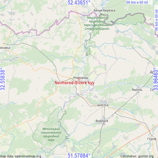
Novhorod-Sivers’kyy GPS coordinates[2]
52° 0' 20.772" North, 33° 15' 41.4" East
| Map corner | latitude | longitude |
|---|---|---|
| Upper-left | 52.43651°, | 32.55838° |
| Center: | 52.00577°, | 33.2615° |
| Lower-right: | 51.57084°, | 33.96463° |
| Map W x H: | 96.3×96.3 km | = 59.8×59.8mi |
| max Lat: | 52.18903° ⇑0.3% North |
| Novhorod-Sivers’kyy: | 52.00577° |
| min Lat: | ⇓99.7% South 44.39214° |
| min Long | Novhorod-Sivers | max Long |
| 22.20555° | 33.2615° | 40.13222° |
| W 49.3%⇐ | ⇒50.7% E |
Elevation
Elevation of Novhorod-Sivers’kyy is 159 m = 522 ft, and this is 3.2 m = 10 ft above average elevation for this country.
| Max E: |
886 m = 2907 ft | 42.8% |
| Novhorod-Sivers’kyy | 159 m 522 ft | |
| Avg. | 155.8 m = 511 ft | |
Min E: |
-3 m = -10 ft | 57.2% |
See also: Ukraine elevation on elevation.city.
Geographical zone
Novhorod-Sivers’kyy is located in North temperate zone (between Tropic of Cancer and the Arctic Circle). Distance of this North polar circle is 1618.7 km =1005.8 mi to North.| Distance of | km | miles | from Novhorod-Sivers’kyy |
|---|---|---|---|
| North Pole | 4224.6 | 2625 | to North |
| Arctic Circle | 1618.7 | 1005.8 | to North |
| Tropic Cancer | 3176.6 | 1973.8 | to South |
| Equator | 5782.5 | 3593.1 | to South |


Nearby cities:
15 places around Novhorod-Sivers’kyy: (largest is in red/bold)
• Avdiyivka
40.7 km =25.3 mi,  231°
231°
• Chuykivka
50.7 km =31.5 mi,  86°
86°
• Druzhba
47 km =29.2 mi,  84°
84°
• Hlukhiv
57.9 km =36 mi,  128°
128°
• Kholmy
47.7 km =29.6 mi,  251°
251°
• Korop
53.1 km =33 mi,  203°
203°
• Koryukivka
74.4 km =46.2 mi, 249°
• Krolevets’
51.6 km =32.1 mi,  170°
170°
• Semenivka
50.2 km =31.2 mi,  292°
292°
• Seredyna-Buda
56.7 km =35.2 mi,  68°
68°
• Shalyhyne
76.4 km =47.5 mi, 129°
• Shostka
21.4 km =13.3 mi,  138°
138°
• Sosnytsya
75 km =46.6 mi,  224°
224°
• Yampil’
36.6 km =22.7 mi,  100°
100°
• Yesman’
61.2 km =38 mi,  115°
115°
Sources, notices
• [Note1] Compared only with cities in Ukraine existing in our database
• [Src1] Map data: © OpenStreetMap contributors (CC-BY-SA)
• [Src2] Other city data from geonames.org with taken over terms of usage.
• [Src3] Geographical zone / Annual Mean Temperature by Robert A. Rohde @ Wikipedia
