Pervomays’k geodata
Pervomays’k (Luhansk) is a populated place; located in Ukraine in Europe/Zaporozhye (GMT+3) time zone. With population of 41,480 people, there are 108 cities with bigger population in this country. Compared to other cities in Ukraine, 58.3% of cities are located further ↓South; 96.9% of cities are located further ←West and 55.5% of cities have lower elevation than Pervomays’k. Note1


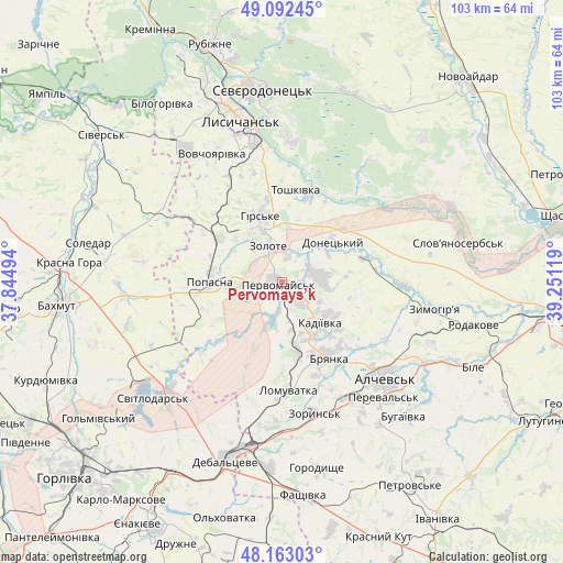
Pervomays’k GPS coordinates[2]
48° 37' 47.568" North, 38° 32' 53.016" East
| Map corner | latitude | longitude |
|---|---|---|
| Upper-left | 49.09245°, | 37.84494° |
| Center: | 48.62988°, | 38.54806° |
| Lower-right: | 48.16303°, | 39.25119° |
| Map W x H: | 103.3×103.3 km | = 64.2×64.2mi |
| max Lat: | 52.18903° ⇑41.7% North |
| Pervomays’k: | 48.62988° |
| min Lat: | ⇓58.3% South 44.39214° |
| min Long | Pervomays’k | max Long |
| 22.20555° | 38.54806° | 40.13222° |
| W 96.9%⇐ | ⇒3.1% E |
Elevation
Elevation of Pervomays’k is 154 m = 505 ft, and this is 1.8 m = 6 ft below average elevation for this country.
| Max E: |
886 m = 2907 ft | 44.5% |
| Avg. | 155.8 m = 511 ft | |
| Pervomays’k | 154 m = 505 ft | |
Min E: |
-3 m = -10 ft | 55.5% |
See also: Pervomays’k elevation on elevation.city.
Geographical zone
Pervomays’k is located in North temperate zone (between Tropic of Cancer and the Arctic Circle). Distance of this North polar circle is 1994 km =1239 mi to North.| Distance of | km | miles | from Pervomays’k |
|---|---|---|---|
| North Pole | 4599.9 | 2858.2 | to North |
| Arctic Circle | 1994 | 1239 | to North |
| Tropic Cancer | 2801.2 | 1740.6 | to South |
| Equator | 5407.1 | 3359.8 | to South |


Nearby cities:
15 places around Pervomays’k: (largest is in red/bold)
• Alchevs’k
26.7 km =16.6 mi,  132°
132°
• Artemivs’k
25 km =15.5 mi,  147°
147°
• Bayrachky
26.7 km =16.6 mi,  171°
171°
• Bryanka
16.1 km =10 mi, 145°
• Hirs’ke
12.3 km =7.6 mi,  341°
341°
• Kadiyivka
9.8 km =6.1 mi, 134°
• Kirovs’k
7 km =4.3 mi,  83°
83°
• Luhans’ke
29.4 km =18.3 mi,  225°
225°
• Lysychans’k
31.5 km =19.6 mi,  345°
345°
• Pereval’s’k
30.5 km =19 mi, 134°
• Popasna
12.5 km =7.8 mi,  271°
271°
• Toshkivka
16.8 km =10.4 mi,  7°
7°
• Voronove
29.8 km =18.5 mi,  3°
3°
• Zoryns’k
24.9 km =15.5 mi, 167°
• Zymohiria
29.1 km =18.1 mi,  99°
99°
Sources, notices
• [Note1] Compared only with cities in Ukraine existing in our database
• [Src1] Map data: © OpenStreetMap contributors (CC-BY-SA)
• [Src2] Other city data from geonames.org with taken over terms of usage.
• [Src3] Geographical zone / Annual Mean Temperature by Robert A. Rohde @ Wikipedia
