Kapitanivka geodata
Kapitanivka (Kirovohrad) is a populated place; located in Ukraine in Europe/Kiev (GMT+3) time zone. With population of 2,945 people, there are 960 cities with bigger population in this country. Compared to other cities in Ukraine, 64.3% of cities are located further ↓South; 58.4% of cities are located further →East and 66.8% of cities have lower elevation than Kapitanivka. Note1


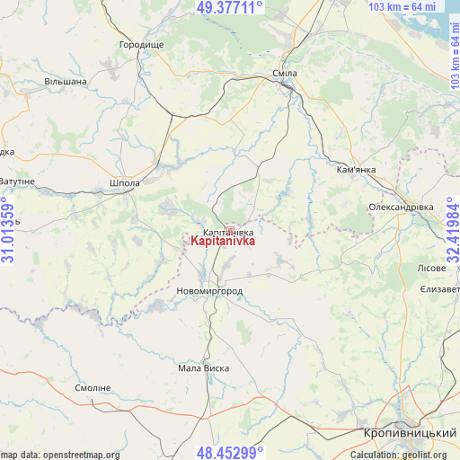
Kapitanivka GPS coordinates[2]
48° 55' 1.884" North, 31° 43' 0.156" East
| Map corner | latitude | longitude |
|---|---|---|
| Upper-left | 49.37711°, | 31.01359° |
| Center: | 48.91719°, | 31.71671° |
| Lower-right: | 48.45299°, | 32.41984° |
| Map W x H: | 102.8×102.8 km | = 63.9×63.9mi |
| max Lat: | 52.18903° ⇑35.7% North |
| Kapitanivka: | 48.91719° |
| min Lat: | ⇓64.3% South 44.39214° |
| min Long | Kapitanivka | max Long |
| 22.20555° | 31.71671° | 40.13222° |
| W 41.6%⇐ | ⇒58.4% E |
Elevation
Elevation of Kapitanivka is 193 m = 633 ft, and this is 37.2 m = 122 ft above average elevation for this country.
| Max E: |
886 m = 2907 ft | 33.2% |
| Kapitanivka | 193 m 633 ft | |
| Avg. | 155.8 m = 511 ft | |
Min E: |
-3 m = -10 ft | 66.8% |
See also: Ukraine elevation on elevation.city.
Geographical zone
Kapitanivka is located in North temperate zone (between Tropic of Cancer and the Arctic Circle). Distance of this North polar circle is 1962.1 km =1219.2 mi to North.| Distance of | km | miles | from Kapitanivka |
|---|---|---|---|
| North Pole | 4568 | 2838.4 | to North |
| Arctic Circle | 1962.1 | 1219.2 | to North |
| Tropic Cancer | 2833.2 | 1760.5 | to South |
| Equator | 5439.1 | 3379.7 | to South |


Nearby cities:
15 places around Kapitanivka: (largest is in red/bold)
• Horodyshche
45.4 km =28.2 mi,  334°
334°
• Kamianka
31 km =19.3 mi,  65°
65°
• Lebedyn
14.7 km =9.1 mi,  289°
289°
• Mala Vyska
31 km =19.3 mi,  190°
190°
• Mliiv
48.9 km =30.4 mi,  342°
342°
• Novomyrhorod
16.1 km =10 mi,  199°
199°
• Oleksandrivka
38.2 km =23.7 mi,  82°
82°
• Shpola
25.5 km =15.8 mi, 292°
• Smila
36.1 km =22.4 mi,  20°
20°
• Tsvitkove
29.2 km =18.1 mi, 333°
• Vatutine
49 km =30.4 mi,  282°
282°
• Yelyzavethradka
51.9 km =32.2 mi,  104°
104°
• Yerky
53.8 km =33.4 mi, 278°
• Yurkivka
47.1 km =29.3 mi, 282°
• Zlynka
49.8 km =30.9 mi, 195°
Sources, notices
• [Note1] Compared only with cities in Ukraine existing in our database
• [Src1] Map data: © OpenStreetMap contributors (CC-BY-SA)
• [Src2] Other city data from geonames.org with taken over terms of usage.
• [Src3] Geographical zone / Annual Mean Temperature by Robert A. Rohde @ Wikipedia
